IMAGES TAKEN NEAR TO
St. Pauls Walk, WAKEFIELD, WF2 0AX
Introduction
This page details the photographs taken nearby to St. Pauls Walk, WF2 0AX by members of the Geograph project.
The Geograph project started in 2005 with the aim of publishing, organising and preserving representative images for every square kilometre of Great Britain, Ireland and the Isle of Man.

There are currently over 7.5m images from over14,400 individuals and you can help contribute to the project by visiting https://www.geograph.org.uk
Image Map
Images are licensed for reuse under creativecommons.org/licenses/by-sa/2.0
Notes
- Clicking on the map will re-center to the selected point.
- The higher the marker number, the further away the image location is from the centre of the postcode.
Image Listing (88 Images Found)
Images are licensed for reuse under creativecommons.org/licenses/by-sa/2.0
Image
Details
Distance
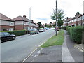
1
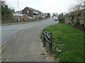
St Paul's Walk, Alverthorpe, Wakefield
A residential cul-de-sac, named after the nearby parish church.
Image: © Christine Johnstone
Taken: 21 Mar 2022
0.02 miles
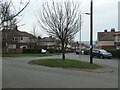
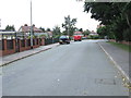
3

Childs Road - viewed from Marion Avenue
Image: © Betty Longbottom
Taken: 10 Sep 2013
0.05 miles
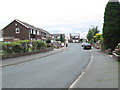
4
Marion Avenue from Childs Road, Alverthorpe
Wakefield Council built this small housing estate in the 1920s.
Image: © Christine Johnstone
Taken: 21 Mar 2022
0.05 miles
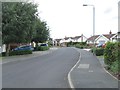
5
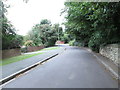
St Paul's Drive - viewed from Childs Road
Image: © Betty Longbottom
Taken: 10 Sep 2013
0.05 miles
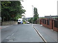
6
Childs Road - viewed from Marion Avenue
Image: © Betty Longbottom
Taken: 10 Sep 2013
0.06 miles

9
St Paul's Drive - viewed from Childs Road
Image: © Betty Longbottom
Taken: 10 Sep 2013
0.09 miles
10
The Mount - viewed from Harewood Drive
Image: © Betty Longbottom
Taken: 10 Sep 2013
0.09 miles