IMAGES TAKEN NEAR TO
Harebell Avenue, WAKEFIELD, WF2 0AQ
Introduction
This page details the photographs taken nearby to Harebell Avenue, WF2 0AQ by members of the Geograph project.
The Geograph project started in 2005 with the aim of publishing, organising and preserving representative images for every square kilometre of Great Britain, Ireland and the Isle of Man.

There are currently over 7.5m images from over14,400 individuals and you can help contribute to the project by visiting https://www.geograph.org.uk
Image Map
Images are licensed for reuse under creativecommons.org/licenses/by-sa/2.0
Notes
- Clicking on the map will re-center to the selected point.
- The higher the marker number, the further away the image location is from the centre of the postcode.
Image Listing (96 Images Found)
Images are licensed for reuse under creativecommons.org/licenses/by-sa/2.0
Image
Details
Distance
2
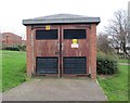
Electricity Substation No 8298 - Larkspur Way
Image: © Betty Longbottom
Taken: 2 Dec 2013
0.04 miles
6
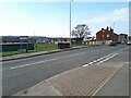
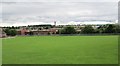
Batley Road, Alverthorpe
There used to be a railway bridge here on the Great Northern Railway's Wakefield to Dewsbury line, but it closed in 1954 and no trace remains.
Image: © Stephen Craven
Taken: 8 Mar 2022
0.06 miles