IMAGES TAKEN NEAR TO
St. Peters Close, BATLEY, WF17 9PW
Introduction
This page details the photographs taken nearby to St. Peters Close, WF17 9PW by members of the Geograph project.
The Geograph project started in 2005 with the aim of publishing, organising and preserving representative images for every square kilometre of Great Britain, Ireland and the Isle of Man.

There are currently over 7.5m images from over14,400 individuals and you can help contribute to the project by visiting https://www.geograph.org.uk
Image Map
Images are licensed for reuse under creativecommons.org/licenses/by-sa/2.0
Notes
- Clicking on the map will re-center to the selected point.
- The higher the marker number, the further away the image location is from the centre of the postcode.
Image Listing (195 Images Found)
Images are licensed for reuse under creativecommons.org/licenses/by-sa/2.0
Image
Details
Distance
2
"Moonrakers", Church Lane, Birstall
I wondered whether the name "Moonrakers" above the door of this property might have been its name as a social club or similar, but it turns out it was a "self-build" dwelling built in the early 1960's (a relative of the owner confirmed this).
It was subsequently purchased by a property developer and demolished in 2018.
Image: © Stephen Craven
Taken: 31 Jul 2017
0.03 miles
3

St Peter's churchyard, Birstall
There are hundreds of burials under the grass, but most of the memorials have been removed. Many of the gravestones have been used for paving. The Nussey tomb, listed Grade II, is near the north-eastern corner of the churchyard. The first burial in it was for John Nussey, who died in 1826. His youngest daughter Ellen Nussey, a friend of Charlotte Bronte, was buried in it in 1897.
Image: © Humphrey Bolton
Taken: 17 Aug 2023
0.03 miles
5
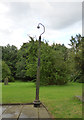
St Peter, Birstall - lamp-post
I presume that this old post at the south-east corner of the church originally supported a gas lamp. It now seems to have a modern, probably LED, fitting.
Image: © Stephen Craven
Taken: 31 Jul 2017
0.04 miles
6
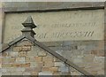
Plaque on former National School, Kirkgate, Birstall
1818 seems an early date for a National School.
Image: © Humphrey Bolton
Taken: 18 Jun 2009
0.04 miles
7
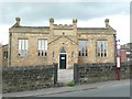
Former National School, Kirkgate, Birstall
Dated 1818 on the plaque, which reads: NATIONAL SCHOOL ERECTED BY WILLIAM CHARLESWORTH ANNO. DOM. MDCCCXVIII. See Image
Image: © Humphrey Bolton
Taken: 18 Jun 2009
0.04 miles
8
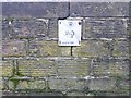
Inscription and washout valve marker plate on Birstall Bridge
The valve is probably on the pipe laid to carry water to Morley from Withens Clough Reservoir. The inscription is mysterious - why Halifax and why no other place name, such as Leeds?
Image: © Humphrey Bolton
Taken: 7 Feb 2013
0.05 miles
9
Church Lane, Birstall
The short length of wall on the right hand side of the road marks the location of the Smithies beck where this road crosses it.
Image: © Stephen Craven
Taken: 31 Jul 2017
0.05 miles
10
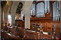
Saint Peter's Church, Kirkgate, Birstall
Image: © Mark Stevenson
Taken: 6 Sep 2016
0.05 miles