IMAGES TAKEN NEAR TO
Oxford Road, BATLEY, WF17 9JR
Introduction
This page details the photographs taken nearby to Oxford Road, WF17 9JR by members of the Geograph project.
The Geograph project started in 2005 with the aim of publishing, organising and preserving representative images for every square kilometre of Great Britain, Ireland and the Isle of Man.

There are currently over 7.5m images from over14,400 individuals and you can help contribute to the project by visiting https://www.geograph.org.uk
Image Map
Images are licensed for reuse under creativecommons.org/licenses/by-sa/2.0
Notes
- Clicking on the map will re-center to the selected point.
- The higher the marker number, the further away the image location is from the centre of the postcode.
Image Listing (235 Images Found)
Images are licensed for reuse under creativecommons.org/licenses/by-sa/2.0
Image
Details
Distance
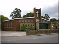
8
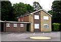
National School - Kirkgate, Birstall
This was built in 1898 by William Charlesworth. It is now used as business premises.
Image: © Betty Longbottom
Taken: 11 Jul 2007
0.08 miles
9
St Patrick's Presbytery - Low Lane, Birstall
Image: © Betty Longbottom
Taken: 11 Jul 2007
0.08 miles
10
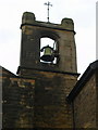
Old St Patrick's Church, Birstall, Bell
Image: © Alexander P Kapp
Taken: 25 Aug 2009
0.08 miles