IMAGES TAKEN NEAR TO
Huddersfield Road, BATLEY, WF17 9EQ
Introduction
This page details the photographs taken nearby to Huddersfield Road, WF17 9EQ by members of the Geograph project.
The Geograph project started in 2005 with the aim of publishing, organising and preserving representative images for every square kilometre of Great Britain, Ireland and the Isle of Man.

There are currently over 7.5m images from over14,400 individuals and you can help contribute to the project by visiting https://www.geograph.org.uk
Image Map
Images are licensed for reuse under creativecommons.org/licenses/by-sa/2.0
Notes
- Clicking on the map will re-center to the selected point.
- The higher the marker number, the further away the image location is from the centre of the postcode.
Image Listing (200 Images Found)
Images are licensed for reuse under creativecommons.org/licenses/by-sa/2.0
Image
Details
Distance
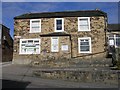
1

Birstall Young Life Centre - Huddersfield Road
Image: © Betty Longbottom
Taken: 9 Mar 2010
0.02 miles
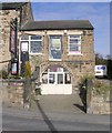
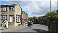
2

The High Street Dental Practice - High Street
Image: © Betty Longbottom
Taken: 9 Mar 2010
0.02 miles
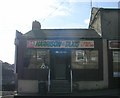
3
Hellewell, Pasley & Brewer - Nelson Street
Image: © Betty Longbottom
Taken: 9 Mar 2010
0.02 miles
6
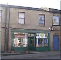
Shapers Unisex Hair Salon - Nelson Street
Image: © Betty Longbottom
Taken: 9 Mar 2010
0.03 miles
7
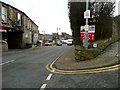
Low Lane at the junction with High Street
The marker plate is for an air valve, probably on the water main from Withens Clough Reservoir to Morley.
Image: © Humphrey Bolton
Taken: 7 Feb 2013
0.03 miles
9
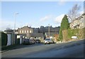
High Street, Birstall
View down High Street as it joins Nelson Street.
Image: © habiloid
Taken: 11 May 2020
0.04 miles
10
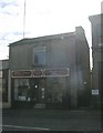
Birstall Antiques Centre - Nelson Street
Image: © Betty Longbottom
Taken: 9 Mar 2010
0.04 miles