IMAGES TAKEN NEAR TO
Smithies Lane, BATLEY, WF17 9DU
Introduction
This page details the photographs taken nearby to Smithies Lane, WF17 9DU by members of the Geograph project.
The Geograph project started in 2005 with the aim of publishing, organising and preserving representative images for every square kilometre of Great Britain, Ireland and the Isle of Man.

There are currently over 7.5m images from over14,400 individuals and you can help contribute to the project by visiting https://www.geograph.org.uk
Image Map
Images are licensed for reuse under creativecommons.org/licenses/by-sa/2.0
Notes
- Clicking on the map will re-center to the selected point.
- The higher the marker number, the further away the image location is from the centre of the postcode.
Image Listing (212 Images Found)
Images are licensed for reuse under creativecommons.org/licenses/by-sa/2.0
Image
Details
Distance
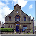
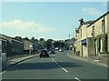
2
Temperance Hall - Smithies Lane, Birstall
Built in 1906, this is now Birstall Community Church
Image: © Betty Longbottom
Taken: 11 Jul 2007
0.02 miles
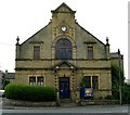
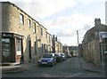
3
Dalesway Conservatories - Smithies Lane
Image: © Betty Longbottom
Taken: 9 Mar 2010
0.02 miles
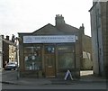
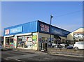
8
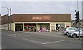
Crillys General Store - Smithies Lane
Image: © Betty Longbottom
Taken: 9 Mar 2010
0.05 miles
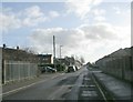
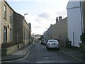
10
School Street - Huddersfield Road
Image: © Betty Longbottom
Taken: 17 Jan 2009
0.05 miles