IMAGES TAKEN NEAR TO
Fieldhead Crescent, BATLEY, WF17 9BP
Introduction
This page details the photographs taken nearby to Fieldhead Crescent, WF17 9BP by members of the Geograph project.
The Geograph project started in 2005 with the aim of publishing, organising and preserving representative images for every square kilometre of Great Britain, Ireland and the Isle of Man.

There are currently over 7.5m images from over14,400 individuals and you can help contribute to the project by visiting https://www.geograph.org.uk
Image Map
Images are licensed for reuse under creativecommons.org/licenses/by-sa/2.0
Notes
- Clicking on the map will re-center to the selected point.
- The higher the marker number, the further away the image location is from the centre of the postcode.
Image Listing (65 Images Found)
Images are licensed for reuse under creativecommons.org/licenses/by-sa/2.0
Image
Details
Distance
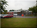
1
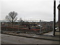
Building Site, Fieldhead Crescent, Batley
Image: © Alex McGregor
Taken: 14 Dec 2010
0.01 miles
3
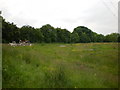
Former cricket field on Owler Lane
Image: © Alexander P Kapp
Taken: 10 Jun 2009
0.05 miles
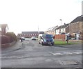
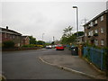
4
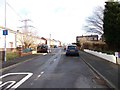
Fieldhead Crescent - Rochester Road
Image: © Betty Longbottom
Taken: 28 Dec 2011
0.05 miles
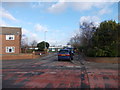
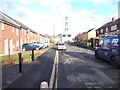
5
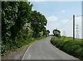
Fieldhead Crescent - Field Head Lane
Image: © Betty Longbottom
Taken: 28 Dec 2011
0.06 miles
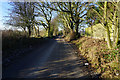
6
Owler Lane, Birstall
A cul-de-sac for motor vehicles.
Image: © Humphrey Bolton
Taken: 3 Jun 2010
0.06 miles