IMAGES TAKEN NEAR TO
West Yorkshire Retail Park, Holden Ing Way, BATLEY, WF17 9AE
Introduction
This page details the photographs taken nearby to West Yorkshire Retail Park, Holden Ing Way, WF17 9AE by members of the Geograph project.
The Geograph project started in 2005 with the aim of publishing, organising and preserving representative images for every square kilometre of Great Britain, Ireland and the Isle of Man.

There are currently over 7.5m images from over14,400 individuals and you can help contribute to the project by visiting https://www.geograph.org.uk
Image Map
Images are licensed for reuse under creativecommons.org/licenses/by-sa/2.0
Notes
- Clicking on the map will re-center to the selected point.
- The higher the marker number, the further away the image location is from the centre of the postcode.
Image Listing (91 Images Found)
Images are licensed for reuse under creativecommons.org/licenses/by-sa/2.0
Image
Details
Distance
1
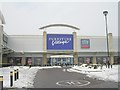
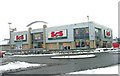
Furniture Village - Birstall Retail Park
Image: © Betty Longbottom
Taken: 4 Feb 2009
0.01 miles
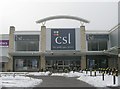
4
Barker & Stonehouse - Birstall Retail Park
Image: © Betty Longbottom
Taken: 4 Feb 2009
0.03 miles
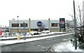
6
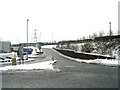
High Wood Road - Birstall Retail Park
Image: © Betty Longbottom
Taken: 4 Feb 2009
0.04 miles
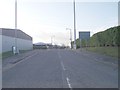
8
High Wood Road - looking towards Gelderd Road
Image: © Betty Longbottom
Taken: 13 Dec 2011
0.07 miles
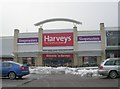
10
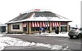
TGI Fridays - Birstall Retail Park
Image: © Betty Longbottom
Taken: 4 Feb 2009
0.07 miles