IMAGES TAKEN NEAR TO
Hayburn Road, BATLEY, WF17 7TW
Introduction
This page details the photographs taken nearby to Hayburn Road, WF17 7TW by members of the Geograph project.
The Geograph project started in 2005 with the aim of publishing, organising and preserving representative images for every square kilometre of Great Britain, Ireland and the Isle of Man.

There are currently over 7.5m images from over14,400 individuals and you can help contribute to the project by visiting https://www.geograph.org.uk
Image Map
Images are licensed for reuse under creativecommons.org/licenses/by-sa/2.0
Notes
- Clicking on the map will re-center to the selected point.
- The higher the marker number, the further away the image location is from the centre of the postcode.
Image Listing (116 Images Found)
Images are licensed for reuse under creativecommons.org/licenses/by-sa/2.0
Image
Details
Distance

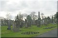

9
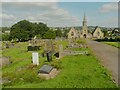
Gravestones and driveway down to the chapels, Batley Cemetery
Image: © Humphrey Bolton
Taken: 17 Aug 2023
0.11 miles
10
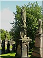
Mourner with anchor, Batley Cemetery
The anchor is a symbol of hope and steadfastness, and eternal life. The mourner is high up on a pedestal and has a good view across the valley.
Image: © Humphrey Bolton
Taken: 17 Aug 2023
0.11 miles