IMAGES TAKEN NEAR TO
Chaster Street, BATLEY, WF17 7SF
Introduction
This page details the photographs taken nearby to Chaster Street, WF17 7SF by members of the Geograph project.
The Geograph project started in 2005 with the aim of publishing, organising and preserving representative images for every square kilometre of Great Britain, Ireland and the Isle of Man.

There are currently over 7.5m images from over14,400 individuals and you can help contribute to the project by visiting https://www.geograph.org.uk
Image Map
Images are licensed for reuse under creativecommons.org/licenses/by-sa/2.0
Notes
- Clicking on the map will re-center to the selected point.
- The higher the marker number, the further away the image location is from the centre of the postcode.
Image Listing (53 Images Found)
Images are licensed for reuse under creativecommons.org/licenses/by-sa/2.0
Image
Details
Distance
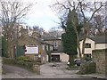
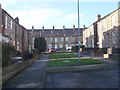
5
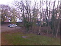
Hotel car park
Car park and gardens at the Alder House Hotel
Image: © Bob Harvey
Taken: 6 Nov 2014
0.05 miles
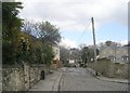
7
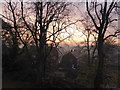
Rooftops on a foggy morning
Looking over the rooftops of early morning Batley
Image: © Bob Harvey
Taken: 6 Nov 2014
0.09 miles
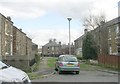

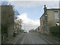
10
Colbeck Terrace - off West Park Road
Image: © Betty Longbottom
Taken: 11 Dec 2012
0.10 miles