IMAGES TAKEN NEAR TO
Upper Road, BATLEY, WF17 7LT
Introduction
This page details the photographs taken nearby to Upper Road, WF17 7LT by members of the Geograph project.
The Geograph project started in 2005 with the aim of publishing, organising and preserving representative images for every square kilometre of Great Britain, Ireland and the Isle of Man.

There are currently over 7.5m images from over14,400 individuals and you can help contribute to the project by visiting https://www.geograph.org.uk
Image Map
Images are licensed for reuse under creativecommons.org/licenses/by-sa/2.0
Notes
- Clicking on the map will re-center to the selected point.
- The higher the marker number, the further away the image location is from the centre of the postcode.
Image Listing (127 Images Found)
Images are licensed for reuse under creativecommons.org/licenses/by-sa/2.0
Image
Details
Distance
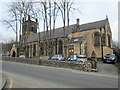
2
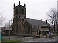
Holy Trinity Church - Upper Road, Batley Carr
Image: © Betty Longbottom
Taken: 15 Feb 2008
0.02 miles
3
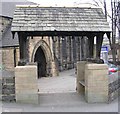
War Memorial Gateway - Holy Trinity Church - Upper Road, Batley Carr
The names of the deceased soldiers etc are inscribed on the inner walls, above the wooden seats.
Image: © Betty Longbottom
Taken: 15 Feb 2008
0.02 miles
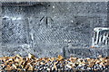
5
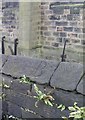
Old Boundary Marker on Holy Trinity boundary wall, Batley Carr
Boundary Marker in parish of Batley and Liversedge (Kirklees District), Batley Carr, on capping stone on North boundary wall of churchyard.
Inscription reads:-
B
Surveyed
Milestone Society National ID: YW_BAT09pb
Image: © Milestone Society
Taken: Unknown
0.03 miles
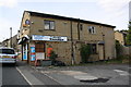
8
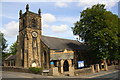
The Trinity Centre at junction of Trinity Street and Upper Road
There is an OS benchmark Image on the south face of the former Holy Trinity Church
Image: © Luke Shaw
Taken: 30 Aug 2018
0.03 miles
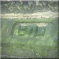
9
Benchmark on the south face of Trinity Community Centre
Ordnance Survey cut mark benchmark described on the Bench Mark Database at www.bench-marks.org.uk/bm78731
Image: © Luke Shaw
Taken: 30 Aug 2018
0.03 miles
10
Old Boundary Marker on Holy Trinity Church, Batley
Parish Boundary Marker by the UC road, in parish of Batley and Liversedge (Kirklees District), Holy Trinity Church, Upper Road, Batley, outside North wall of the church.
Surveyed
Milestone Society National ID: YW_BAT07pb
Image: © Milestone Society
Taken: Unknown
0.03 miles