IMAGES TAKEN NEAR TO
Wards Place, BATLEY, WF17 7HL
Introduction
This page details the photographs taken nearby to Wards Place, WF17 7HL by members of the Geograph project.
The Geograph project started in 2005 with the aim of publishing, organising and preserving representative images for every square kilometre of Great Britain, Ireland and the Isle of Man.

There are currently over 7.5m images from over14,400 individuals and you can help contribute to the project by visiting https://www.geograph.org.uk
Image Map
Images are licensed for reuse under creativecommons.org/licenses/by-sa/2.0
Notes
- Clicking on the map will re-center to the selected point.
- The higher the marker number, the further away the image location is from the centre of the postcode.
Image Listing (66 Images Found)
Images are licensed for reuse under creativecommons.org/licenses/by-sa/2.0
Image
Details
Distance
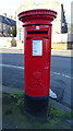
4
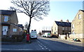
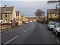
West Park Road (B6123), Batley
Showing position of Postbox No. WF17 114.
See Image] for postbox.
Image: © JThomas
Taken: 27 Feb 2020
0.05 miles
5
Elizabeth II postbox on West Park Road, Batley
Postbox No. WF17 114.
See Image] for context.
Image: © JThomas
Taken: 27 Feb 2020
0.05 miles
7
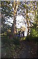
Pedestrian entrance to Dryfield House, Healey, Batley
This view through two stone gateposts, with a glimpse of the house through the screen of woodland, just asked to be photographed!
Image: © Humphrey Bolton
Taken: 16 Nov 2005
0.05 miles
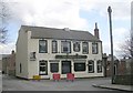
8
Healey Lane, Healey, Batley
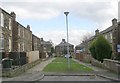
Healey was a hamlet separate from Batley, and started to grow in the 19C when there were two textile mills. The George Inn is the focal point, at the junction of Healey lane and Deighton Lane. The 19C houses ranged from small back-to-backs to the large houses of mill-managers and professional. At the western end streets were developed up the slope to the north of Healey lane, and a Methodist Chapel was built at the end of one of these (Healey Street).
Image: © Humphrey Bolton
Taken: 16 Nov 2005
0.05 miles
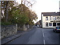
10
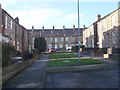
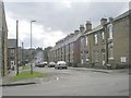
Colbeck Terrace - off West Park Road
Image: © Betty Longbottom
Taken: 11 Dec 2012
0.05 miles