IMAGES TAKEN NEAR TO
Grange Road, BATLEY, WF17 7AT
Introduction
This page details the photographs taken nearby to Grange Road, WF17 7AT by members of the Geograph project.
The Geograph project started in 2005 with the aim of publishing, organising and preserving representative images for every square kilometre of Great Britain, Ireland and the Isle of Man.

There are currently over 7.5m images from over14,400 individuals and you can help contribute to the project by visiting https://www.geograph.org.uk
Image Map
Images are licensed for reuse under creativecommons.org/licenses/by-sa/2.0
Notes
- Clicking on the map will re-center to the selected point.
- The higher the marker number, the further away the image location is from the centre of the postcode.
Image Listing (83 Images Found)
Images are licensed for reuse under creativecommons.org/licenses/by-sa/2.0
Image
Details
Distance
4
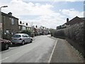
St Mary's Avenue - looking towards Track Road
Image: © Betty Longbottom
Taken: 23 Apr 2013
0.07 miles
6
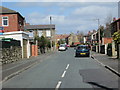
Thorncliffe Road - off Halifax Road
Image: © Betty Longbottom
Taken: 23 Apr 2013
0.07 miles
9
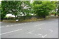
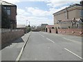
Junction of Thorncliffe Road and Sycamore Court
Ordnance Survey documents indicate that in 1962 a benchmark levelled at 124.560m above Newlyn Datum was verified on a wall near a gateway at the entrance to a sports ground then at this location
Image: © Luke Shaw
Taken: 25 May 2019
0.10 miles
10
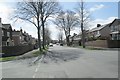
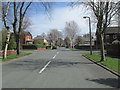
Norfolk Avenue - St Mary's Avenue
Image: © Betty Longbottom
Taken: 23 Apr 2013
0.10 miles