IMAGES TAKEN NEAR TO
Commonside, BATLEY, WF17 6LA
Introduction
This page details the photographs taken nearby to Commonside, WF17 6LA by members of the Geograph project.
The Geograph project started in 2005 with the aim of publishing, organising and preserving representative images for every square kilometre of Great Britain, Ireland and the Isle of Man.

There are currently over 7.5m images from over14,400 individuals and you can help contribute to the project by visiting https://www.geograph.org.uk
Image Map
Images are licensed for reuse under creativecommons.org/licenses/by-sa/2.0
Notes
- Clicking on the map will re-center to the selected point.
- The higher the marker number, the further away the image location is from the centre of the postcode.
Image Listing (111 Images Found)
Images are licensed for reuse under creativecommons.org/licenses/by-sa/2.0
Image
Details
Distance
1
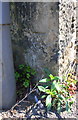
Benchmark on stone post at road end of wall at entrance to #104 Commonside
Ordnance Survey cut mark benchmark levelled at 86.444m above Newlyn Datum and verified in 1962
Image: © Roger Templeman
Taken: 19 Apr 2019
0.01 miles
2
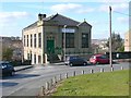
Former chapel, Bromley Street, Soothill
This was a Methodist chapel and is now used by the Muslims.
Image: © Humphrey Bolton
Taken: 4 Mar 2010
0.03 miles
3
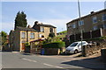
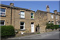
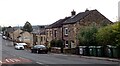
Houses on Commonside (house numbers around 100) and bus stop
There is an Ordnance Survey benchmark Image on the stone post next to the lamppost
Image: © Roger Templeman
Taken: 19 Apr 2019
0.03 miles
5
Jamia Al Saeed Mosque, Bromley Street, Batley
Image: © habiloid
Taken: 30 Sep 2022
0.04 miles
6
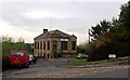
Open space at the southwest end of Bromley Street
Ordnance Survey documents indicate that in 1962 a benchmark levelled at 84.945m above Newlyn Datum was verified on house #25 here
Image: © Roger Templeman
Taken: 19 Apr 2019
0.07 miles
7
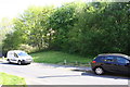
Junction of grass track (Nursery Wood Road) with footpath
There is an Ordnance Survey benchmark Image on a stone post hidden in the bush at the left hand side of the image
Image: © Roger Templeman
Taken: 19 Apr 2019
0.07 miles
8
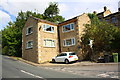
Nos. 109 and 113 Commonside
Ordnance Survey documents indicate that in 1962 a benchmark levelled at 94.010m above Newlyn Datum was verified on a gatepost in the gap between the two houses. The post appears to have been removed to widen the access.
Image: © Roger Templeman
Taken: 19 Apr 2019
0.08 miles
10
Nos. 31 and 33 Jack Lane at Peter Hill junction
Ordnance Survey records indicate there was a benchmark levelled at 63.746m above Newlyn Datum in 1962 on the near corner of the left hand house but its quoins appear new and no benchmark was found. See www.bench-marks.org.uk/bm78184 for details.
Image: © Luke Shaw
Taken: 30 Aug 2018
0.09 miles