IMAGES TAKEN NEAR TO
Bromley Road, BATLEY, WF17 6EH
Introduction
This page details the photographs taken nearby to Bromley Road, WF17 6EH by members of the Geograph project.
The Geograph project started in 2005 with the aim of publishing, organising and preserving representative images for every square kilometre of Great Britain, Ireland and the Isle of Man.

There are currently over 7.5m images from over14,400 individuals and you can help contribute to the project by visiting https://www.geograph.org.uk
Image Map
Images are licensed for reuse under creativecommons.org/licenses/by-sa/2.0
Notes
- Clicking on the map will re-center to the selected point.
- The higher the marker number, the further away the image location is from the centre of the postcode.
Image Listing (95 Images Found)
Images are licensed for reuse under creativecommons.org/licenses/by-sa/2.0
Image
Details
Distance
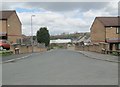
1
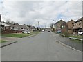
Bromley Road - viewed from Heaton Grange
Image: © Betty Longbottom
Taken: 30 Apr 2013
0.02 miles
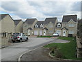
4

Bromley Road - viewed from Heaton Grange
Image: © Betty Longbottom
Taken: 30 Apr 2013
0.04 miles
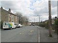
8
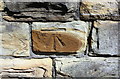
Benchmark on wall outside #57 Mill Lane
Ordnance Survey cut mark benchmark levelled at 89.855m and verified in 1962
Image: © Roger Templeman
Taken: 19 Apr 2019
0.06 miles