IMAGES TAKEN NEAR TO
Mill Lane, BATLEY, WF17 6DZ
Introduction
This page details the photographs taken nearby to Mill Lane, WF17 6DZ by members of the Geograph project.
The Geograph project started in 2005 with the aim of publishing, organising and preserving representative images for every square kilometre of Great Britain, Ireland and the Isle of Man.

There are currently over 7.5m images from over14,400 individuals and you can help contribute to the project by visiting https://www.geograph.org.uk
Image Map
Images are licensed for reuse under creativecommons.org/licenses/by-sa/2.0
Notes
- Clicking on the map will re-center to the selected point.
- The higher the marker number, the further away the image location is from the centre of the postcode.
Image Listing (100 Images Found)
Images are licensed for reuse under creativecommons.org/licenses/by-sa/2.0
Image
Details
Distance
1
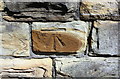
Benchmark on wall outside #57 Mill Lane
Ordnance Survey cut mark benchmark levelled at 89.855m and verified in 1962
Image: © Roger Templeman
Taken: 19 Apr 2019
0.01 miles
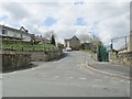
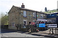
2
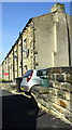
Houses on Mill Lane
There is an Ordnance Survey benchmark Image on the stone in the wall with a brown stain near the right hand edge of the image
Image: © Roger Templeman
Taken: 19 Apr 2019
0.04 miles
6
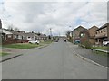
Bromley Road - viewed from Heaton Grange
Image: © Betty Longbottom
Taken: 30 Apr 2013
0.05 miles
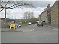
7

Mill Lane - viewed from High Street
Image: © Betty Longbottom
Taken: 30 Apr 2013
0.06 miles
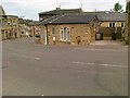
9
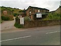
Thornhill Motors, Commonside
Business up for sale
Image: © Alex McGregor
Taken: 28 Jun 2011
0.06 miles
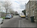
10
#120 Commonside
Ordnance Survey documents indicate that a cut mark benchmark levelled at 102.462m above Newlyn Datum on the near corner, road face, of the house was verified in 1962. The mark is now covered by a cement skirt applied to the house road face
Image: © Roger Templeman
Taken: 19 Apr 2019
0.06 miles