IMAGES TAKEN NEAR TO
Soothill Lane, BATLEY, WF17 5ST
Introduction
This page details the photographs taken nearby to Soothill Lane, WF17 5ST by members of the Geograph project.
The Geograph project started in 2005 with the aim of publishing, organising and preserving representative images for every square kilometre of Great Britain, Ireland and the Isle of Man.

There are currently over 7.5m images from over14,400 individuals and you can help contribute to the project by visiting https://www.geograph.org.uk
Image Map
Images are licensed for reuse under creativecommons.org/licenses/by-sa/2.0
Notes
- Clicking on the map will re-center to the selected point.
- The higher the marker number, the further away the image location is from the centre of the postcode.
Image Listing (215 Images Found)
Images are licensed for reuse under creativecommons.org/licenses/by-sa/2.0
Image
Details
Distance
1
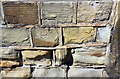
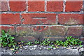
Benchmark on Grove House Surgery, Soothill Lane
Ordnance Survey cut mark benchmark levelled at 64.167m above Newlyn Datum and verified in 1962
Image: © Roger Templeman
Taken: 19 Apr 2019
0.02 miles
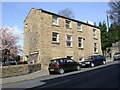
2
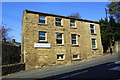
Grove House Surgery (NHS), Soothill Lane
There is an Ordnance Survey benchmark Image on the front of the building near its far corner
Image: © Roger Templeman
Taken: 19 Apr 2019
0.03 miles
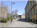
3
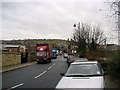
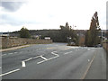
Upper Station Road, Batley
Not an easy road to negotiate if you're driving a wagon. I had just watched one struggling to get through. Over the wall to the left is the premises of Angloco http://www.angloco.co.uk/.
Image: © Stephen Armstrong
Taken: 7 Dec 2009
0.03 miles
4
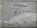
Ordnance Survey Cut Mark
This mark or what remains of it can be found on a bridge in Soothill Lane.
For more detail see : http://www.bench-marks.org.uk/bm42775
Image: © Peter Wood
Taken: 28 Apr 2012
0.04 miles
5
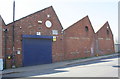
Factory on west side of Upper Station Road
There is an Ordnance Survey benchmark Image on the wall of the building about 2 feet from its far end
Image: © Roger Templeman
Taken: 19 Apr 2019
0.04 miles
8
Grove House Surgery - Soothill Lane
Image: © Betty Longbottom
Taken: 20 Apr 2010
0.05 miles
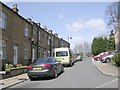
9
Soothill Lane bridge
The 1933 1:2500 map shows a total of twelve tracks, including sidings, passing under Soothill Lane bridge. Upper Station Road leads off to the left.
Image: © Stephen Craven
Taken: 8 Sep 2019
0.05 miles
10
Benchmark on works building on west side of Upper Station Road
Ordnance Survey cut mark benchmark described on the Bench Mark Database at www.bench-marks.org.uk/bm59366
Image: © Roger Templeman
Taken: 19 Apr 2019
0.05 miles