IMAGES TAKEN NEAR TO
Lark Hill, BATLEY, WF17 0QR
Introduction
This page details the photographs taken nearby to Lark Hill, WF17 0QR by members of the Geograph project.
The Geograph project started in 2005 with the aim of publishing, organising and preserving representative images for every square kilometre of Great Britain, Ireland and the Isle of Man.

There are currently over 7.5m images from over14,400 individuals and you can help contribute to the project by visiting https://www.geograph.org.uk
Image Map
Images are licensed for reuse under creativecommons.org/licenses/by-sa/2.0
Notes
- Clicking on the map will re-center to the selected point.
- The higher the marker number, the further away the image location is from the centre of the postcode.
Image Listing (47 Images Found)
Images are licensed for reuse under creativecommons.org/licenses/by-sa/2.0
Image
Details
Distance
2
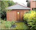
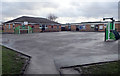
Electricity Substation No 5130 - Upper Batley Lane
Image: © Betty Longbottom
Taken: 6 Aug 2012
0.06 miles
3
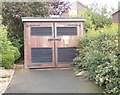
Electricity Substation No 55208 - Woodlands Road
Image: © Betty Longbottom
Taken: 6 Aug 2012
0.06 miles
5
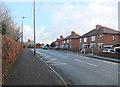
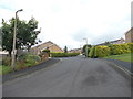
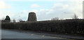
Upper Batley Lane, Batley
Windmill Primary School is behind the hedge on the left.
Image: © habiloid
Taken: 8 Dec 2019
0.11 miles
7
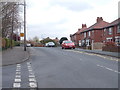
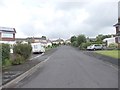
Upper Batley Lane - viewed from Windmill Lane
Image: © Betty Longbottom
Taken: 7 Apr 2012
0.13 miles
8
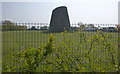
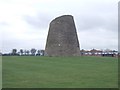
Windmill Stump
The remains of a windmill in the grounds of Windmill CE Primary School, seen from Windmill Lane.
Image: © habiloid
Taken: 17 Apr 2019
0.13 miles
10
Windmill stump, Batley
This remnant of a windmill is in the grounds of Windmill Primary school on Windmill Lane.
Image: © habiloid
Taken: 8 Dec 2019
0.14 miles