IMAGES TAKEN NEAR TO
Arundel Walk, BATLEY, WF17 0JP
Introduction
This page details the photographs taken nearby to Arundel Walk, WF17 0JP by members of the Geograph project.
The Geograph project started in 2005 with the aim of publishing, organising and preserving representative images for every square kilometre of Great Britain, Ireland and the Isle of Man.

There are currently over 7.5m images from over14,400 individuals and you can help contribute to the project by visiting https://www.geograph.org.uk
Image Map
Images are licensed for reuse under creativecommons.org/licenses/by-sa/2.0
Notes
- Clicking on the map will re-center to the selected point.
- The higher the marker number, the further away the image location is from the centre of the postcode.
Image Listing (61 Images Found)
Images are licensed for reuse under creativecommons.org/licenses/by-sa/2.0
Image
Details
Distance
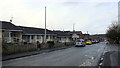
2
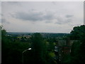
Upper Batley
This view of Upper Batley includes Emley Moor TV mast away in the distance. Upper Batley is much more upmarket than Batley. The houses are bigger and in many cases were the homes of turn of the century mill owners who chose to live higher than the smog of their own mills
Image: © Dr Brian Lynch
Taken: 10 Jan 2000
0.04 miles
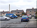

9
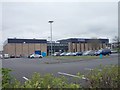
Batley Sports & Tennis Centre - Windmill Lane
Image: © Betty Longbottom
Taken: 7 Apr 2012
0.08 miles