IMAGES TAKEN NEAR TO
Ashfield Close, BATLEY, WF17 0HF
Introduction
This page details the photographs taken nearby to Ashfield Close, WF17 0HF by members of the Geograph project.
The Geograph project started in 2005 with the aim of publishing, organising and preserving representative images for every square kilometre of Great Britain, Ireland and the Isle of Man.

There are currently over 7.5m images from over14,400 individuals and you can help contribute to the project by visiting https://www.geograph.org.uk
Image Map
Images are licensed for reuse under creativecommons.org/licenses/by-sa/2.0
Notes
- Clicking on the map will re-center to the selected point.
- The higher the marker number, the further away the image location is from the centre of the postcode.
Image Listing (86 Images Found)
Images are licensed for reuse under creativecommons.org/licenses/by-sa/2.0
Image
Details
Distance
2
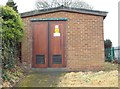
Electricity Substation No 5759 - Leeds Road
Image: © Betty Longbottom
Taken: 7 Apr 2012
0.03 miles
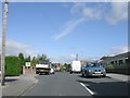
5
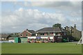
Birstall Cricket Club Pavilion - Leeds Road
Image: © Betty Longbottom
Taken: 29 Aug 2009
0.04 miles
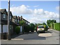
6
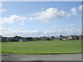
Birstall Cricket Club Ground - Leeds Road
Image: © Betty Longbottom
Taken: 29 Aug 2009
0.04 miles
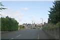
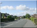
9
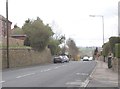
Leeds Road - viewed from Moat Hill Farm Drive
Image: © Betty Longbottom
Taken: 7 Apr 2012
0.08 miles
