IMAGES TAKEN NEAR TO
Rock Farm Court, BATLEY, WF17 0BP
Introduction
This page details the photographs taken nearby to Rock Farm Court, WF17 0BP by members of the Geograph project.
The Geograph project started in 2005 with the aim of publishing, organising and preserving representative images for every square kilometre of Great Britain, Ireland and the Isle of Man.

There are currently over 7.5m images from over14,400 individuals and you can help contribute to the project by visiting https://www.geograph.org.uk
Image Map
Images are licensed for reuse under creativecommons.org/licenses/by-sa/2.0
Notes
- Clicking on the map will re-center to the selected point.
- The higher the marker number, the further away the image location is from the centre of the postcode.
Image Listing (35 Images Found)
Images are licensed for reuse under creativecommons.org/licenses/by-sa/2.0
Image
Details
Distance
1
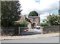
Blocked driveway to Elmwood House, Old Hall Road, Batley
Elmwood House was the 19th century residence of Benjamin Sheard, woollen manufacturer and founder of the Batley Rifle Volunteers (source: https://vivientomlinson.com/batley/p3.htm ). Most of the house appears to have been demolished and as the drive has been blocked off it is no longer accessible.
Image: © Stephen Craven
Taken: 8 Sep 2019
0.02 miles
2
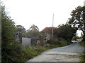
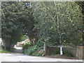
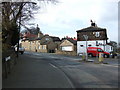
Junction of Old Hall Road and Upper Batley Low Lane.
Old Hall Lane leads, as you might expect, to what was Batley Hall which is now a nursing a home. Many of the rural out buildings are houses. Also down the road is the site of Upper Batley Railway Station http://www.geograph.org.uk/photo/771059 where there was a level crossing of which the gate posts can still be seen.
Image: © Gary Hughes
Taken: 21 Apr 2008
0.03 miles
3
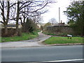
Upper Batley Low Lane - viewed from Old Hall Road
Image: © Betty Longbottom
Taken: 8 Aug 2012
0.03 miles
4
Upper Batley Low Lane - viewed from Old Hall Road
Image: © Betty Longbottom
Taken: 8 Aug 2012
0.04 miles
5
Hollycroft Farm - Upper Batley Low Lane
Image: © Betty Longbottom
Taken: 8 Aug 2012
0.05 miles
6
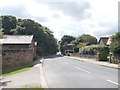
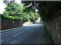
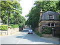
Old Hall Road, Batley
The widening of the road in the foreground is where the Great Northern Railway's Batley branch crossed the road; Upper Batley station was to the left, of which the converted station building remains Image The station was open for almost exactly 100 years from 1864 to 1964.
Image: © Stephen Craven
Taken: 8 Sep 2019
0.05 miles
7
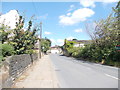
Upper Batley Low Lane
Looking towards Upper Batley Lane this shot shows Upper Batley Low Lane in spring. Except for some fresh tarmac, the road has looked like this for many years including the lack of a pavement up one side where the simple original road edging can be seen. Croft Farm is in the distance on the left hand side and closer to the photographer on the left hand side is the walled gardens of Marshfield. Over the wall to the right hand side are a number of houses, most notably Elmwood House which has been empty for a number of years.
Image: © Gary Hughes
Taken: 3 Jun 2007
0.07 miles
8
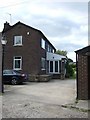
Station House, Old Hall Road, Upper Batley.
This house is the original station building on the platform of Upper Batley railway station.
Image: © Gary Hughes
Taken: 26 Aug 2007
0.08 miles
9
Upper Batley Low Lane
This is the junction of Upper Batley Low Lane with Carlinghow Lane in Upper Batley. Marshfields (the house) is to the left and a gate house is seen to the right.
Image: © Gary Hughes
Taken: 3 Jun 2007
0.08 miles
10
Junction of Upper Batley Low Lane and Upper Batley Lane
Upper Batley's rural past is shown in this photograph of the bottom end of Upper Batley Lane.
Image: © Gary Hughes
Taken: 21 Apr 2008
0.09 miles