IMAGES TAKEN NEAR TO
Cannon Grove, HECKMONDWIKE, WF16 9AT
Introduction
This page details the photographs taken nearby to Cannon Grove, WF16 9AT by members of the Geograph project.
The Geograph project started in 2005 with the aim of publishing, organising and preserving representative images for every square kilometre of Great Britain, Ireland and the Isle of Man.

There are currently over 7.5m images from over14,400 individuals and you can help contribute to the project by visiting https://www.geograph.org.uk
Image Map
Images are licensed for reuse under creativecommons.org/licenses/by-sa/2.0
Notes
- Clicking on the map will re-center to the selected point.
- The higher the marker number, the further away the image location is from the centre of the postcode.
Image Listing (109 Images Found)
Images are licensed for reuse under creativecommons.org/licenses/by-sa/2.0
Image
Details
Distance
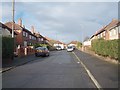
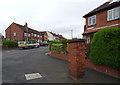
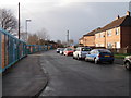
2
Curwen Crescent - viewed from Bevor Crescent
Image: © Betty Longbottom
Taken: 23 Nov 2012
0.05 miles
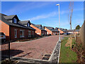
3
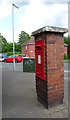
Postbox at the end of Lincoln Avenue
A postbox built into a free-standing pillar at the junction of Lincoln Avenue and Dale Lane.
Image: © habiloid
Taken: 6 Jun 2019
0.06 miles
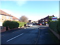
4
Lincoln Avenue - viewed from Bevor Crescent
Image: © Betty Longbottom
Taken: 23 Nov 2012
0.06 miles
7
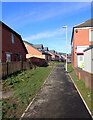
Path between Dale Lane and Leyburn Avenue, Batley
Image: © habiloid
Taken: 1 Mar 2022
0.07 miles
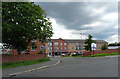
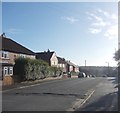
9
Dale Lane - viewed from Fairfield Avenue
Image: © Betty Longbottom
Taken: 4 Dec 2012
0.07 miles
