IMAGES TAKEN NEAR TO
The Crofts, HECKMONDWIKE, WF16 0DS
Introduction
This page details the photographs taken nearby to The Crofts, WF16 0DS by members of the Geograph project.
The Geograph project started in 2005 with the aim of publishing, organising and preserving representative images for every square kilometre of Great Britain, Ireland and the Isle of Man.

There are currently over 7.5m images from over14,400 individuals and you can help contribute to the project by visiting https://www.geograph.org.uk
Image Map
Images are licensed for reuse under creativecommons.org/licenses/by-sa/2.0
Notes
- Clicking on the map will re-center to the selected point.
- The higher the marker number, the further away the image location is from the centre of the postcode.
Image Listing (110 Images Found)
Images are licensed for reuse under creativecommons.org/licenses/by-sa/2.0
Image
Details
Distance
1
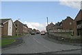
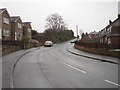
Common Road - viewed from Bunkers Lane
Image: © Betty Longbottom
Taken: 4 Dec 2012
0.04 miles
2
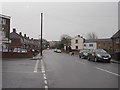
Common Road - viewed from Bunkers Lane
Image: © Betty Longbottom
Taken: 4 Dec 2012
0.04 miles
5
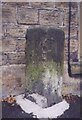
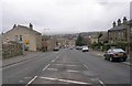
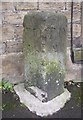
Old Milestone, A638, Halifax Road, Staincliffe Bottom
Heckmondwike. Located on the South side of road, outside No. 123. Carved stone post, 18th century. Alternative view see http://www.geograph.org.uk/photo/344388
Inscription reads: TO / H / (9) M // TO / W / 7 M
Grade II listed by Historic England. see https://historicengland.org.uk/listing/the-list/list-entry/1300337
Milestone Society National ID: YW_WKHA07
Image: © Christine Minto
Taken: 4 Feb 2006
0.06 miles
6
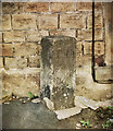
Old Milestone, A638, Halifax Road, Staincliffe Bottom
Heckmondwike. Located on the South side of road, outside No. 123. Carved stone post, 18th century.
Inscription reads: TO / H / (9) M :: TO / W / 7 M
Grade II listed by Historic England. https://historicengland.org.uk/listing/the-list/list-entry/1300337
Milestone Society National ID: YW_WKHA07
Image: © Tony Cree
Taken: 29 Sep 2022
0.06 miles
8
Milestone, Halifax Road, Batley
This is not marked on any of my OS maps, not even the 1850 6” map. It was probably erected by the turnpike trust, and is inscribed 'TO H' (for Halifax) on one face and 'TO W (?) M' on the other (W for Wakefield, M for miles). The distance is about 7 miles.
Image: © Humphrey Bolton
Taken: 20 Feb 2007
0.06 miles
9
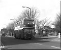
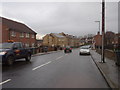
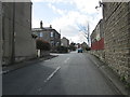
Heckmondwike, Yorkshire
Most bus services in and around Heckmondwike were provided by the Yorkshire Woollen District company. When the West Yorkshire passenger Transport Executive was formed, it took control of YWD's services, although the company remained part of the National Bus Company. Therefore, most YWD buses were repainted into the PTE's Verona green and cream livery, but a few, as here, retained the NBC red (albeit with WYPTE decals).
Image: © Dr Neil Clifton
Taken: 2 Apr 1986
0.06 miles