IMAGES TAKEN NEAR TO
Lascelles Road, HECKMONDWIKE, WF16 0DF
Introduction
This page details the photographs taken nearby to Lascelles Road, WF16 0DF by members of the Geograph project.
The Geograph project started in 2005 with the aim of publishing, organising and preserving representative images for every square kilometre of Great Britain, Ireland and the Isle of Man.

There are currently over 7.5m images from over14,400 individuals and you can help contribute to the project by visiting https://www.geograph.org.uk
Image Map
Images are licensed for reuse under creativecommons.org/licenses/by-sa/2.0
Notes
- Clicking on the map will re-center to the selected point.
- The higher the marker number, the further away the image location is from the centre of the postcode.
Image Listing (105 Images Found)
Images are licensed for reuse under creativecommons.org/licenses/by-sa/2.0
Image
Details
Distance
1
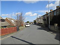
Kilpin Hill Lane - viewed from Harewood Avenue
Image: © Betty Longbottom
Taken: 16 Apr 2013
0.03 miles
4
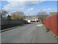
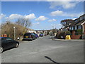
Harewood Avenue - Kilpin Hill Lane
Image: © Betty Longbottom
Taken: 16 Apr 2013
0.04 miles
5
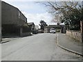
Kilpin Hill Lane - viewed from Harewood Avenue
Image: © Betty Longbottom
Taken: 16 Apr 2013
0.05 miles
7
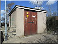
Electricity Substation No 1826 - Heights Lane
Image: © Betty Longbottom
Taken: 16 Apr 2013
0.06 miles
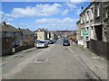
8
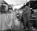
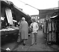
Heckmondwyke Market
Two old women appraise the goods on offer at this old-established Yorkshire open air market.
Image: © Dr Neil Clifton
Taken: 20 Aug 1985
0.07 miles