
IMAGES TAKEN NEAR TO
Heath, WAKEFIELD, WF1 5ST
Introduction
This page details the photographs taken nearby to WF1 5ST by members of the Geograph project.
The Geograph project started in 2005 with the aim of publishing, organising and preserving representative images for every square kilometre of Great Britain, Ireland and the Isle of Man.

There are currently over 7.5m images from over14,400 individuals and you can help contribute to the project by visiting https://www.geograph.org.uk
Image Map
Images are licensed for reuse under creativecommons.org/licenses/by-sa/2.0
Notes
- Clicking on the map will re-center to the selected point.
- The higher the marker number, the further away the image location is from the centre of the postcode.
Image Listing (135 Images Found)
Images are licensed for reuse under creativecommons.org/licenses/by-sa/2.0
Image
Details
Distance
1

The Priest House, Heath
Part of the old Heath Hall estate and built about 1650 and it was used in 1811 by a group of Benedictine nuns fleeing the French revolution who were staying at the Hall
Image: © Stanley Walker
Taken: 19 Sep 2010
0.07 miles
2

Fields on the edge of Heath
Just west of Kirkthorpe Lane http://www.geograph.org.uk/photo/5839927 as it leaves the village and Heath Common http://www.geograph.org.uk/photo/5839935 lie a few fields on elevated ground above the River Calder. On the other side of the river is Wakefield's sewage treatment plant. The city centre with the cathedral spire can be seen ahead in Image
Image: © Rudi Winter
Taken: 1 Jul 2018
0.07 miles
3

Heath House, Heath
Overlooking the attractive village green is James Paine's first commission, dating from 1744 when he was only 21. A noble front, the centre of which has an attached Ionic portico. Grade II* listed.
Image: © Stephen Richards
Taken: 14 Aug 2002
0.08 miles
4

Gate Piers to Old Heath Hall
The old Heath Hall was built in 1595 and demolished in the 1960's the lodge gate piers are all that remain
Image: © Stanley Walker
Taken: 19 Sep 2010
0.08 miles
5

Heath conservation village - Heath House (1)
Heath House, a Grade II* listed large country house, mid C17. Refenestrated and with addition forming a new front, c1744 by James Paine for the Hopkinson family. Ashlar front, hammer- dressed stone to rear, Welsh blue-slate and lead flat roof.
The house is of national importance, both historically and architecturally.
LBS No: 342395
Image: © Mike Kirby
Taken: 12 Jun 2010
0.08 miles
6

Heath House
A 17th/18th century country house on the northern edge of the village. Listed grade II* (list entry 1200517). Now converted to apartments.
Image: © Stephen Craven
Taken: 10 Sep 2022
0.09 miles
7

The Priest's House, Heath
A 17th century house, with more recent alterations. Listed grade II (list entry 1313214).
Image: © Stephen Craven
Taken: 10 Sep 2022
0.09 miles
8

Heath conservation village - The Priest's House
A grade II listed building. Mid-late C17 altered mid C20. Rendered stonework, and a stone slate roof.
LBS No: 342394
Image: © Mike Kirby
Taken: 12 Jun 2010
0.09 miles
9

Plaque to Eliza Gleadall
The plaque was placed in 2022 on the wall adjacent to the gateway to Heath Old Hall Image
Image: © Stephen Craven
Taken: 10 Sep 2022
0.09 miles
10
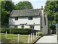
The Priest's House, Heath
The oldest house in the village, dating from the mid-late 17th century, Listed Grade II.
Image: © Alan Murray-Rust
Taken: 1 Jul 2018
0.09 miles