IMAGES TAKEN NEAR TO
Cuniver Court, LIVERSEDGE, WF15 8LR
Introduction
This page details the photographs taken nearby to Cuniver Court, WF15 8LR by members of the Geograph project.
The Geograph project started in 2005 with the aim of publishing, organising and preserving representative images for every square kilometre of Great Britain, Ireland and the Isle of Man.

There are currently over 7.5m images from over14,400 individuals and you can help contribute to the project by visiting https://www.geograph.org.uk
Image Map
Images are licensed for reuse under creativecommons.org/licenses/by-sa/2.0
Notes
- Clicking on the map will re-center to the selected point.
- The higher the marker number, the further away the image location is from the centre of the postcode.
Image Listing (84 Images Found)
Images are licensed for reuse under creativecommons.org/licenses/by-sa/2.0
Image
Details
Distance
3
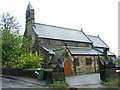
St Barnabas Church, Hightown, Liversedge
Image: © Bill Henderson
Taken: 15 May 2009
0.04 miles
4
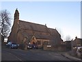
St Barnabas, Hightown: exterior
Viewed from Church Street.
Image: © Stephen Craven
Taken: 15 Jan 2016
0.04 miles
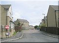
5
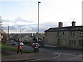
Halifax Road, Hightown
From the end of Church Street. The smoke in the distance is from Hare Park Mills, although I have not managed to identify the nature of the industry there.
Image: © Stephen Craven
Taken: 15 Jan 2016
0.04 miles
6
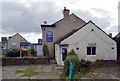
Mayflower Fisheries, Halifax Road (A649), Liversedge
Image: © habiloid
Taken: 20 Mar 2020
0.04 miles
8
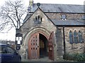
St Barnabas church, Hightown: porch
Entrance to the church is through the south-west porch.
Image: © Stephen Craven
Taken: 15 Jan 2016
0.05 miles
9
Mayflower Fisheries - Halifax Road
Image: © Betty Longbottom
Taken: 14 Nov 2012
0.05 miles
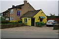
10
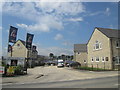
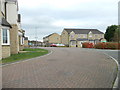
Housing development at Saffron Park, Hightown
Image: © John Slater
Taken: 1 Jul 2014
0.05 miles