IMAGES TAKEN NEAR TO
Windy Bank Lane, LIVERSEDGE, WF15 8AG
Introduction
This page details the photographs taken nearby to Windy Bank Lane, WF15 8AG by members of the Geograph project.
The Geograph project started in 2005 with the aim of publishing, organising and preserving representative images for every square kilometre of Great Britain, Ireland and the Isle of Man.

There are currently over 7.5m images from over14,400 individuals and you can help contribute to the project by visiting https://www.geograph.org.uk
Image Map
Images are licensed for reuse under creativecommons.org/licenses/by-sa/2.0
Notes
- Clicking on the map will re-center to the selected point.
- The higher the marker number, the further away the image location is from the centre of the postcode.
Image Listing (110 Images Found)
Images are licensed for reuse under creativecommons.org/licenses/by-sa/2.0
Image
Details
Distance
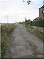
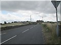
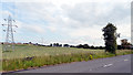
1
Windy Bank Lane
Windy Bank Lane seen from its junction with School Lane, Hartshead.
Image: © habiloid
Taken: 29 Jun 2019
0.05 miles
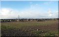
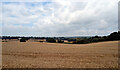
2
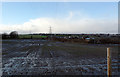
Muddy field seen from School Lane, Hartshead
Image: © habiloid
Taken: 12 Feb 2020
0.05 miles
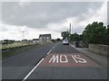
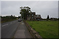
3
Windy Bank Lane - viewed from Peep Green Road
Image: © Betty Longbottom
Taken: 2 Aug 2013
0.05 miles
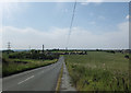
5
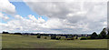
View from Windy Bank Lane, Liversedge
Hightown can be seen in the distance.
Image: © habiloid
Taken: 10 Jul 2020
0.06 miles
7
Field by Windy Bank Lane, Beggarington, Hartshead
Image: © habiloid
Taken: 16 Aug 2021
0.06 miles