IMAGES TAKEN NEAR TO
Hill Side Rise, LIVERSEDGE, WF15 7EW
Introduction
This page details the photographs taken nearby to Hill Side Rise, WF15 7EW by members of the Geograph project.
The Geograph project started in 2005 with the aim of publishing, organising and preserving representative images for every square kilometre of Great Britain, Ireland and the Isle of Man.

There are currently over 7.5m images from over14,400 individuals and you can help contribute to the project by visiting https://www.geograph.org.uk
Image Map
Images are licensed for reuse under creativecommons.org/licenses/by-sa/2.0
Notes
- Clicking on the map will re-center to the selected point.
- The higher the marker number, the further away the image location is from the centre of the postcode.
Image Listing (163 Images Found)
Images are licensed for reuse under creativecommons.org/licenses/by-sa/2.0
Image
Details
Distance
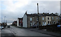
1
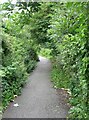
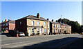
Footpath - Huddersfield Road on right
Image: © Betty Longbottom
Taken: 2 Aug 2008
0.01 miles
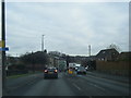
3
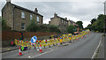
Roadworks, Huddersfield Road (A62), Liversedge
Image: © habiloid
Taken: 27 Aug 2024
0.02 miles
4
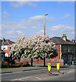
Junction of Strawberry Avenue and Huddersfield Road (A62), Liversedge
Image: © habiloid
Taken: 29 Apr 2022
0.03 miles
8
Strawberry Avenue - Huddersfield Road
Image: © Betty Longbottom
Taken: 1 May 2013
0.03 miles
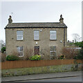
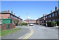
10
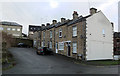
Dymond View, Liversedge
Dymond View seen from Hindley Road.
Image: © habiloid
Taken: 12 Jan 2020
0.04 miles