IMAGES TAKEN NEAR TO
Ferry Close, WF1 4GL
Introduction
This page details the photographs taken nearby to Ferry Close, WF1 4GL by members of the Geograph project.
The Geograph project started in 2005 with the aim of publishing, organising and preserving representative images for every square kilometre of Great Britain, Ireland and the Isle of Man.

There are currently over 7.5m images from over14,400 individuals and you can help contribute to the project by visiting https://www.geograph.org.uk
Image Map
Images are licensed for reuse under creativecommons.org/licenses/by-sa/2.0
Notes
- Clicking on the map will re-center to the selected point.
- The higher the marker number, the further away the image location is from the centre of the postcode.
Image Listing (71 Images Found)
Images are licensed for reuse under creativecommons.org/licenses/by-sa/2.0
Image
Details
Distance
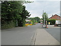
2
Unsigned footpath (5)
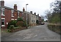
The final leg of the path on route to the A642, passes Stanley Hall.
See Image
Image: © Mike Kirby
Taken: 25 Apr 2011
0.09 miles
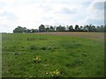
4
Bellway's building site at Wakefield's City Fields
The first of the new houses on the eastern fringe of Wakefield.
Image: © Christine Johnstone
Taken: 15 Dec 2017
0.13 miles
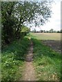
5
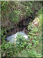
Unsigned footpath (4)
A small stream runs alongside the footpath. Here a very small waterfall has caused the pool below to foam, possibly due to soap from a household drain contaminating the stream.
Image: © Mike Kirby
Taken: 25 Apr 2011
0.13 miles

7
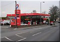
Total Filling Station - Aberford Road
Image: © Betty Longbottom
Taken: 8 Apr 2008
0.14 miles
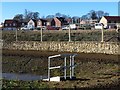
8
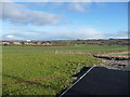
Wakefield's City Fields, ready for development [12]
View from the stub of a new road on the north-east side of the A6194 roundabout. The plan is to build houses here, on the eastern fringe of Wakefield.
Image: © Christine Johnstone
Taken: 15 Dec 2017
0.14 miles
10

Shell Filling Station - viewed from Finkin Lane
Image: © Betty Longbottom
Taken: 14 Jan 2014
0.15 miles