IMAGES TAKEN NEAR TO
St. Clair Street, WAKEFIELD, WF1 4DS
Introduction
This page details the photographs taken nearby to St. Clair Street, WF1 4DS by members of the Geograph project.
The Geograph project started in 2005 with the aim of publishing, organising and preserving representative images for every square kilometre of Great Britain, Ireland and the Isle of Man.

There are currently over 7.5m images from over14,400 individuals and you can help contribute to the project by visiting https://www.geograph.org.uk
Image Map
Images are licensed for reuse under creativecommons.org/licenses/by-sa/2.0
Notes
- Clicking on the map will re-center to the selected point.
- The higher the marker number, the further away the image location is from the centre of the postcode.
Image Listing (381 Images Found)
Images are licensed for reuse under creativecommons.org/licenses/by-sa/2.0
Image
Details
Distance


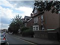
3
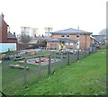
First Steps Day Nursery - Peterson Road
Image: © Betty Longbottom
Taken: 4 Mar 2014
0.03 miles
5
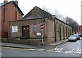
Wakefield Spiritualists - Peterson Road
Image: © Betty Longbottom
Taken: 16 Jan 2008
0.04 miles
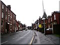
8
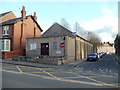
Wakefield Spiritualist National Union Church
Image: © Bill Henderson
Taken: 12 Jan 2012
0.06 miles
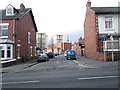
9
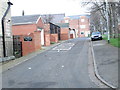
Back Peterson Road - Berners Street
Image: © Betty Longbottom
Taken: 4 Mar 2014
0.07 miles
10
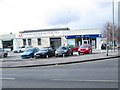
The Mount Dental Practice - Peterson Road
Image: © Betty Longbottom
Taken: 4 Mar 2014
0.07 miles