IMAGES TAKEN NEAR TO
Windhill Road, WAKEFIELD, WF1 4DD
Introduction
This page details the photographs taken nearby to Windhill Road, WF1 4DD by members of the Geograph project.
The Geograph project started in 2005 with the aim of publishing, organising and preserving representative images for every square kilometre of Great Britain, Ireland and the Isle of Man.

There are currently over 7.5m images from over14,400 individuals and you can help contribute to the project by visiting https://www.geograph.org.uk
Image Map (Loading...)


Getting Data...Please wait
Leaflet Map data © OpenStreetMap
Images are licensed for reuse under creativecommons.org/licenses/by-sa/2.0
Notes
- Clicking on the map will re-center to the selected point.
- The higher the marker number, the further away the image location is from the centre of the postcode.
Image Listing (67 Images Found)
Images are licensed for reuse under creativecommons.org/licenses/by-sa/2.0
Image
Details
Distance
2
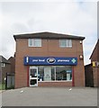
Eastmoor Health Centre - Windhill Road
Image: © Betty Longbottom
Taken: 13 May 2014
0.04 miles
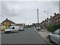
3
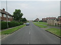
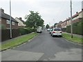
Windhill Road - viewed from Garsdale Grove
Image: © Betty Longbottom
Taken: 13 May 2014
0.04 miles
5
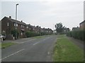
Arncliffe Road - off Windhill Road
Image: © Betty Longbottom
Taken: 20 May 2014
0.05 miles
7

Electricity Substation No 5378 - Fewston Avenue
Image: © Betty Longbottom
Taken: 13 May 2014
0.06 miles
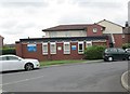
8
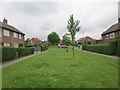
1-4 Garsdale Grove, Eastmoor, Wakefield
This part of Eastmoor was built in the 1950s - low density semis, with lots of green space. Many men who lived here worked at the nearby Parkhill Colliery.
Image: © Christine Johnstone
Taken: 5 May 2020
0.06 miles
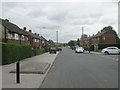
9
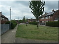
Windhill Road - viewed from Garsdale Grove
Image: © Betty Longbottom
Taken: 13 May 2014
0.07 miles