IMAGES TAKEN NEAR TO
Selby Street, WAKEFIELD, WF1 3PQ
Introduction
This page details the photographs taken nearby to Selby Street, WF1 3PQ by members of the Geograph project.
The Geograph project started in 2005 with the aim of publishing, organising and preserving representative images for every square kilometre of Great Britain, Ireland and the Isle of Man.

There are currently over 7.5m images from over14,400 individuals and you can help contribute to the project by visiting https://www.geograph.org.uk
Image Map
Images are licensed for reuse under creativecommons.org/licenses/by-sa/2.0
Notes
- Clicking on the map will re-center to the selected point.
- The higher the marker number, the further away the image location is from the centre of the postcode.
Image Listing (240 Images Found)
Images are licensed for reuse under creativecommons.org/licenses/by-sa/2.0
Image
Details
Distance
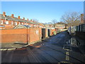
1
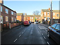
Selby Street - looking towards Pinderfields Road
Image: © Betty Longbottom
Taken: 2 Jan 2014
0.02 miles
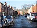
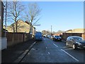
3
Edward Street - Duke of York Street
Image: © Betty Longbottom
Taken: 2 Jan 2014
0.05 miles

5
St Mark's Street - Pinderfields Road
Image: © Betty Longbottom
Taken: 2 Jan 2014
0.06 miles
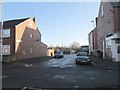
6
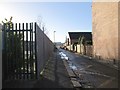
Back Duke of York Street - viewed from Edward Street
Image: © Betty Longbottom
Taken: 2 Jan 2014
0.06 miles
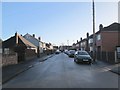
7
Smirthwaite Street - Pinderfields Road
Image: © Betty Longbottom
Taken: 2 Jan 2014
0.06 miles
8
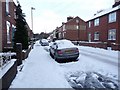
Pinderfields Road in the snow
None of Wakefield's side streets is being cleared, unless the residents do it themselves.
Image: © Christine Johnstone
Taken: 2 Dec 2010
0.06 miles
9
Back Duke of York Street - viewed from Edward Street
Image: © Betty Longbottom
Taken: 2 Jan 2014
0.06 miles
10
Duke of York Street - looking towards Jacob's Well Lane
Image: © Betty Longbottom
Taken: 2 Jan 2014
0.07 miles