IMAGES TAKEN NEAR TO
Potter Mews, WAKEFIELD, WF1 3FD
Introduction
This page details the photographs taken nearby to Potter Mews, WF1 3FD by members of the Geograph project.
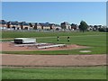
The Geograph project started in 2005 with the aim of publishing, organising and preserving representative images for every square kilometre of Great Britain, Ireland and the Isle of Man.

There are currently over 7.5m images from over14,400 individuals and you can help contribute to the project by visiting https://www.geograph.org.uk
Image Map
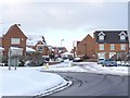
Images are licensed for reuse under creativecommons.org/licenses/by-sa/2.0
Notes
- Clicking on the map will re-center to the selected point.
- The higher the marker number, the further away the image location is from the centre of the postcode.
Image Listing (94 Images Found)
Images are licensed for reuse under creativecommons.org/licenses/by-sa/2.0
Image
Details
Distance
1
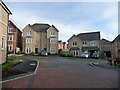
Junction of Wolfenden Way and Harrison Close, Wakefield
Part of Avant Homes' Gateway estate.
Image: © Christine Johnstone
Taken: 16 Dec 2018
0.04 miles
2
The march of bricks and mortar, north of Westfield View
The second stage of the new Gateway development, seen from Long Causeway.
Image: © Christine Johnstone
Taken: 15 Dec 2017
0.04 miles
3
Avant Homes' new Gateway development
The march of bricks and mortar west of Wakefield's Pinderfields Hospital.
Image: © Christine Johnstone
Taken: 15 Dec 2017
0.05 miles
4
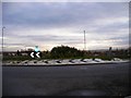
Roundabout on St John's Walk
Looking south towards Wakefield centre.
Image: © SMJ
Taken: 15 Nov 2008
0.06 miles
5
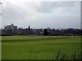
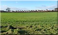
View of North Wakefield
A view over playing fields taken from the junction of North Avenue and Bar Lane,(a fairly new road linking the A61 and A642). From left to right, Bishopgarth police training school, St John’s Church and Emley Moor TV mast.
Image: © Mike Kirby
Taken: 25 Jan 2009
0.07 miles
6
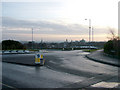
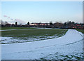
Snowy sunset across Wakefield
In the foreground a roundabout in the fairly new road linking the M1 access road to the Pinderfields Hospital area provides access to a new housing estate. Behind that there is the running track, then the skyline features the high buildings of the city centre, such as the Cathedral (seen above the roundabout).
Image: © John Goldsmith
Taken: 28 Dec 2009
0.07 miles
7
Frost at mid-day, Harrison Close, Wakefield
On the north side of the houses.
Image: © Christine Johnstone
Taken: 31 Dec 2020
0.07 miles
8
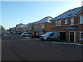
New houses in Harrison Close and Wolfenden Way
Mostly with solar panels on their south-facing roofs.
Image: © Christine Johnstone
Taken: 6 May 2020
0.08 miles
9
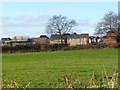
Trent Bridge Way, leading to Spinners Avenue and Boundary Drive
In the previous two days, there had been about nine inches of snow, without a thaw.
Image: © Christine Johnstone
Taken: 7 Jan 2010
0.08 miles