
IMAGES TAKEN NEAR TO
King Street, WAKEFIELD, WF1 2SN
Introduction
This page details the photographs taken nearby to King Street, WF1 2SN by members of the Geograph project.
The Geograph project started in 2005 with the aim of publishing, organising and preserving representative images for every square kilometre of Great Britain, Ireland and the Isle of Man.

There are currently over 7.5m images from over14,400 individuals and you can help contribute to the project by visiting https://www.geograph.org.uk
Image Map
Images are licensed for reuse under creativecommons.org/licenses/by-sa/2.0
Notes
- Clicking on the map will re-center to the selected point.
- The higher the marker number, the further away the image location is from the centre of the postcode.
Image Listing (1093 Images Found)
Images are licensed for reuse under creativecommons.org/licenses/by-sa/2.0
Image
Details
Distance
1
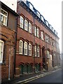
King Street
This former Council building is currently undergoing some restoration.
Image: © Mike Kirby
Taken: 26 Oct 2008
0.01 miles
2
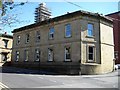
Town Hall Chambers (2)
See Image A view of the 5 bay front to Cliff Parade.
A grade II listed building, LBS No.444466
Image: © Mike Kirby
Taken: 26 Mar 2012
0.01 miles
3
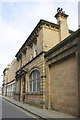
#26 King Street (former police station?)
There is an OS benchmark Image on the roadface of the near corner pier
Image: © Roger Templeman
Taken: 3 Sep 2012
0.01 miles
4
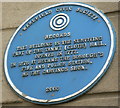
Blue Plaque, Cliff Parade, Wakefield
This is on a building which is now part of the Magistrates Court. The Blue Plaque tells us "This building is the surviving part of the Tammy (cloth) Hall opened in 1777. In 1878 it became the borough's fire and police station, as the carvings show".
The carved head of a policeman or fireman can be seen above the door in Image] with the blue plaque to the left of the door.
More information can be seen on the Wakefield Civic Society website http://www.wakefieldcivicsociety.org.uk/?i=82&s=1111
Image: © Rich Tea
Taken: 20 Jun 2006
0.01 miles
5
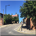
Northeast and uphill on Cliff Parade, Wakefield
Seen from the corner of Cheapside.
Image: © Robin Stott
Taken: 30 Jun 2018
0.01 miles
6
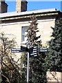
New Street furniture in Cliff Parade
Note, the ornate signpost, See Image, has been replaced by this functional one. Similar signposts are replacing the originals all over the city.
Image: © Mike Kirby
Taken: 26 Mar 2012
0.01 miles
7
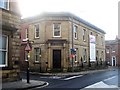
Town Hall Chambers
Located at the top of King Street, opposite Tammy Hall. It was purpose built in 1863 as a Probate Office, and is a grade II listed building. It is currently undergoing conversion into apartments.
Image: © Mike Kirby
Taken: 26 Oct 2008
0.01 miles
8
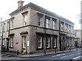
Tammy Hall
Tammy Hall, a large grade II listed building erected for the sale of a special locally produced worsted cloth in the 1770’s. LBS No. 441739
After various other users in the mid nineteenth century, the building was purchased by the Corporation in 1876 and was altered and refaced to provide a Borough Police Station and Fire Station. It is now part of the Magistrates Court. Image
Image: © Mike Kirby
Taken: 26 Oct 2008
0.02 miles
9
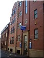
King Street Health Centre
Opened June 2009, seeImage, the NHS Wakefield District Walk-In Centre is at 47 King Street, and offers general medical services for patients that live within the Wakefield area.
Image: © Mike Kirby
Taken: 26 Mar 2012
0.02 miles
10
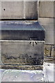
Benchmark on #26 King Street
Ordnance Survey cut mark benchmark described on the Bench Mark Database at http://www.bench-marks.org.uk/bm45207
Image: © Roger Templeman
Taken: 3 Sep 2012
0.02 miles