
IMAGES TAKEN NEAR TO
Denby Dale Road, WAKEFIELD, WF1 1HR
Introduction
This page details the photographs taken nearby to Denby Dale Road, WF1 1HR by members of the Geograph project.
The Geograph project started in 2005 with the aim of publishing, organising and preserving representative images for every square kilometre of Great Britain, Ireland and the Isle of Man.

There are currently over 7.5m images from over14,400 individuals and you can help contribute to the project by visiting https://www.geograph.org.uk
Image Map
Images are licensed for reuse under creativecommons.org/licenses/by-sa/2.0
Notes
- Clicking on the map will re-center to the selected point.
- The higher the marker number, the further away the image location is from the centre of the postcode.
Image Listing (258 Images Found)
Images are licensed for reuse under creativecommons.org/licenses/by-sa/2.0
Image
Details
Distance

2
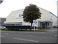
Xercise4Less - main entrance
This former carpet warehouse on Denby Dale Road is now a fitness centre.
Image: © Mike Kirby
Taken: 21 Sep 2011
0.02 miles
3

Raines House, Denby Dale Road
Raines Business Centre, in Raines House, is a small centre which prides itself on a professional but friendly service with a comprehensive range of facilities. The range includes virtual services, secretarial, recruitment and computer training.
Image: © Mike Kirby
Taken: 28 Dec 2008
0.02 miles
4

Xercise4Less - annexe
This former carpet warehouse on Denby Dale Road is now a fitness centre. The annexe to the front of the building houses the exercise bikes.
Image: © Mike Kirby
Taken: 21 Sep 2011
0.02 miles
5

Bridge DOL2 2 - over the A636 - Denby Dale Road
Image: © Betty Longbottom
Taken: 17 Jun 2008
0.03 miles
6

Old milestone
On the bridge over the Ings Beck on the Denby Dale road out of Wakefield, A636, is this ancient stone plaque built into the wall. The eroded legends read as follows To Bretton () Miles/Holmfirth ( ) Do/Staley Bridge ( ) Do/Manchester ( ) Do. The mileages don't appear to have been inscribed so maybe they were painted on or had not been measured.
The blue plaque next to it notes the junction of two Turnpike roads but the style of the lettering on the stone may indicate it preceded the turnpike era. It is Grade II listed.
Image: © Chris Minto
Taken: 10 Jul 2022
0.04 miles
7

Blue plaque
The legend on the plaque shows that the two turnpike roads were fairly late additions to the turnpike era. Both were initially enacted well into the 19thC when many tollroads had already been operative for over half a century. The Ings had an especially short life of just over 30 years.
Image: © Chris Minto
Taken: 10 Jul 2022
0.04 miles
8

Plaque on Denby Dale Road Bridge
The bridge has been rebuilt recently with the loss of a benchmark dating from turnpike road days. See http://www.bench-marks.org.uk/bm40399
Image: © Roger Templeman
Taken: 3 Sep 2012
0.04 miles
9

Denby Dale Road Bridge
This is a modern replacement of an old bridge on turnpike roads which are described on a plaque Image on the other side of the parapet. There was an Ordnance Survey benchmark on the original bridge, http://www.bench-marks.org.uk/bm40399
Image: © Roger Templeman
Taken: 3 Sep 2012
0.04 miles
10
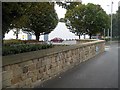
Ings Beck bridge, Denby Dale Road (1)
Originally a grade II listed bridge over Ings Beck, it has now replaced by a modern structure. The stonework of the bridge has been preserved, along with the milestone and a blue plaque to mark the site.
Image: © Mike Kirby
Taken: 21 Sep 2009
0.04 miles