
IMAGES TAKEN NEAR TO
Ash Lea, KNOTTINGLEY, WF11 9LF
Introduction
This page details the photographs taken nearby to Ash Lea, WF11 9LF by members of the Geograph project.
The Geograph project started in 2005 with the aim of publishing, organising and preserving representative images for every square kilometre of Great Britain, Ireland and the Isle of Man.

There are currently over 7.5m images from over14,400 individuals and you can help contribute to the project by visiting https://www.geograph.org.uk
Image Map
Images are licensed for reuse under creativecommons.org/licenses/by-sa/2.0
Notes
- Clicking on the map will re-center to the selected point.
- The higher the marker number, the further away the image location is from the centre of the postcode.
Image Listing (76 Images Found)
Images are licensed for reuse under creativecommons.org/licenses/by-sa/2.0
Image
Details
Distance
1

Road removal at Fairburn
The former A1 dual-carriageway has been replaced by a motorway to the east of the village. One carriageway is being removed, returning the village to its pre-war calm (well, when the diggers have left, anyway).
Image: © Toby Speight
Taken: 20 Jun 2005
0.05 miles
2

Top Fold
Top Fold and a footpath leading to North Road.
Image: © DS Pugh
Taken: 18 Mar 2023
0.10 miles
3

Lunnsfield Lane
Looking towards Fairburn from the east of the village.
Image: © DS Pugh
Taken: 9 Jan 2022
0.11 miles
4

Great North Road, Fairburn
Once a snarling dual carriageway now reduced but still dividing the east and west parts of Fairburn.
Image: © Jonathan Thacker
Taken: 28 May 2018
0.12 miles
5
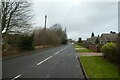
Houses on Lunnsfield Lane
Looking along Lunnsfield Lane in Fairburn.
Image: © DS Pugh
Taken: 9 Jan 2022
0.13 miles
6

Fairburn Village viewed from Fryston Woods
The sunlight reflects off the houses in Fairburn on a snowy winters day.
Image: © derek dye
Taken: 22 Jan 2013
0.13 miles

8

Fairburn War Memorial
War Memorial in St Peters churchyard Fairburn
Image: © derek dye
Taken: 5 May 2011
0.13 miles

10

Fairburn, St James's Church
This Church is just north west of centre of the O/S grid it occupies,
Image: © Bill Henderson
Taken: Unknown
0.14 miles