IMAGES TAKEN NEAR TO
Aire Street, KNOTTINGLEY, WF11 9AT
Introduction
This page details the photographs taken nearby to Aire Street, WF11 9AT by members of the Geograph project.
The Geograph project started in 2005 with the aim of publishing, organising and preserving representative images for every square kilometre of Great Britain, Ireland and the Isle of Man.

There are currently over 7.5m images from over14,400 individuals and you can help contribute to the project by visiting https://www.geograph.org.uk
Image Map
Images are licensed for reuse under creativecommons.org/licenses/by-sa/2.0
Notes
- Clicking on the map will re-center to the selected point.
- The higher the marker number, the further away the image location is from the centre of the postcode.
Image Listing (152 Images Found)
Images are licensed for reuse under creativecommons.org/licenses/by-sa/2.0
Image
Details
Distance
3
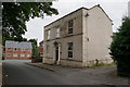
Holly House
Set opposite Knottingley parish church, this early 19th century house forms the front of an L-shaped courtyard, another part of which is shown on the 1907 map as a school. It is listed grade II (list entry 1266187) although older looking properties in the same town are not. When listed in 1987 it was described as a library, but it is obviously no longer in use as such.
Image: © Stephen Craven
Taken: 13 Aug 2022
0.04 miles
4
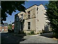
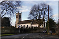
St Botolph's church, Knottingley: east end
The gate shown here is locked; the only access to the church is through the parish room gardens. For a history of the church see Image
Image: © Stephen Craven
Taken: 13 Aug 2022
0.04 miles
5
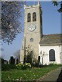
St Botolph's Church Tower - Chapel Street
Image: © Betty Longbottom
Taken: 21 Mar 2009
0.04 miles
6
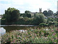
St Botolph's Church, Knottingley.
This is the view of the Church seen from the northern bank of the River Aire.
Image: © Bill Henderson
Taken: 12 Sep 2007
0.05 miles
7
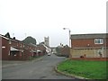
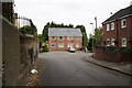
Aire Street, Knottingley, looking west towards St Botolph's Church
Image: © Bill Henderson
Taken: 24 Sep 2006
0.05 miles
10
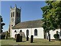
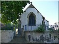
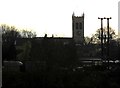
St Botolph's church, Knottingley: south side and tower
There has been a church here since Norman times (if not earlier), built by Henry de Lacy, Lord of the manor, as chapel of ease to All Saints, Pontefract.
The present church dates from c.1750, initially without a tower. The tower was built in the 1830s after the fashion of that time. It was heightened in 1887 to mark the Golden Jubilee of Queen Victoria along with the rebuilding of the Chancel and removal of the galleries. It had 'tubular' bells initially, but in 1995 these were replaced with a ring of ten conventional bells in memory of Revd Edward Beaumont, Vicar of Knottingley 1954 - 1970 (sources: parish website and HE listing, grade II, entry 1225755).
Image: © Stephen Craven
Taken: 13 Aug 2022
0.06 miles