IMAGES TAKEN NEAR TO
Prospect Terrace, KNOTTINGLEY, WF11 9AH
Introduction
This page details the photographs taken nearby to Prospect Terrace, WF11 9AH by members of the Geograph project.
The Geograph project started in 2005 with the aim of publishing, organising and preserving representative images for every square kilometre of Great Britain, Ireland and the Isle of Man.

There are currently over 7.5m images from over14,400 individuals and you can help contribute to the project by visiting https://www.geograph.org.uk
Image Map
Images are licensed for reuse under creativecommons.org/licenses/by-sa/2.0
Notes
- Clicking on the map will re-center to the selected point.
- The higher the marker number, the further away the image location is from the centre of the postcode.
Image Listing (214 Images Found)
Images are licensed for reuse under creativecommons.org/licenses/by-sa/2.0
Image
Details
Distance
1
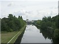
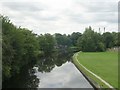
Aire and Calder Navigation Knottingley
From the Ropewalk.
Image: © Steve Fareham
Taken: 26 Jan 2008
0.02 miles
5
Aire & Calder Navigation - Weeland Road
Image: © Betty Longbottom
Taken: 27 Aug 2010
0.03 miles
6
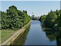
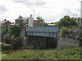
Aire and Calder Navigation east from Jackson's Bridge
Image: © Stephen Craven
Taken: 13 Aug 2022
0.04 miles
7
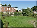
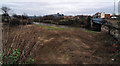
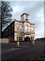
Open space by Jackson's Bridge
This space next to the Aire and Calder Navigation, is not currently built on, but has a retaining wall to the road called Ropewalk. Was this where the ropes were actually made or did it have some other use, perhaps as a canal wharf? Old maps don't offer any clues. The brick building is the former Town Hall Image
Image: © Stephen Craven
Taken: 13 Aug 2022
0.04 miles
8
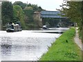
Jacksons Bridge
Narrowboats, line astern, passing under Jacksons Bridge.
Image: © Bill Henderson
Taken: 22 Sep 2007
0.04 miles
10
Aire & Calder Navigation - Weeland Road
Image: © Betty Longbottom
Taken: 27 Aug 2010
0.05 miles