IMAGES TAKEN NEAR TO
Middleton Way, KNOTTINGLEY, WF11 8HA
Introduction
This page details the photographs taken nearby to Middleton Way, WF11 8HA by members of the Geograph project.
The Geograph project started in 2005 with the aim of publishing, organising and preserving representative images for every square kilometre of Great Britain, Ireland and the Isle of Man.

There are currently over 7.5m images from over14,400 individuals and you can help contribute to the project by visiting https://www.geograph.org.uk
Image Map
Images are licensed for reuse under creativecommons.org/licenses/by-sa/2.0
Notes
- Clicking on the map will re-center to the selected point.
- The higher the marker number, the further away the image location is from the centre of the postcode.
Image Listing (149 Images Found)
Images are licensed for reuse under creativecommons.org/licenses/by-sa/2.0
Image
Details
Distance
1
Knottingley Conservative Club - Hill Top
Image: © Betty Longbottom
Taken: 27 Aug 2010
0.03 miles
2
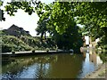
Private mooring in Knottingley
One property along the Aire and Calder Navigation has a private garden extending into the canal, with their own motor launch moored at one end.
Image: © Stephen Craven
Taken: 13 Aug 2022
0.04 miles
3
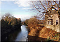
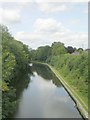
Knottingley and Goole canal
Viewed from bridge in centre of Knottingley.
Image: © derek dye
Taken: 22 Jan 2018
0.04 miles
6
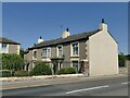
Old house on Hill Top, Knottingley
The building is not listed, but the porticoed entrance suggests an early 19th century date or earlier. Unusually it is built end-on to the road.
Image: © Stephen Craven
Taken: 13 Aug 2022
0.05 miles
7

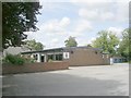
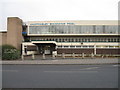
Knottingley Swimming Pool - Hill Top
Image: © Betty Longbottom
Taken: 27 Aug 2010
0.06 miles
9
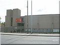
Knottingley Sports Centre - Hill Top
Image: © Betty Longbottom
Taken: 27 Aug 2010
0.06 miles
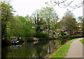
10
Aire & Calder Navigation - Hill Top
Image: © Betty Longbottom
Taken: 27 Aug 2010
0.07 miles