IMAGES TAKEN NEAR TO
Springfields, KNOTTINGLEY, WF11 8BJ
Introduction
This page details the photographs taken nearby to Springfields, WF11 8BJ by members of the Geograph project.
The Geograph project started in 2005 with the aim of publishing, organising and preserving representative images for every square kilometre of Great Britain, Ireland and the Isle of Man.

There are currently over 7.5m images from over14,400 individuals and you can help contribute to the project by visiting https://www.geograph.org.uk
Image Map
Images are licensed for reuse under creativecommons.org/licenses/by-sa/2.0
Notes
- Clicking on the map will re-center to the selected point.
- The higher the marker number, the further away the image location is from the centre of the postcode.
Image Listing (76 Images Found)
Images are licensed for reuse under creativecommons.org/licenses/by-sa/2.0
Image
Details
Distance
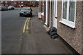
1
Banks Garth House, Weeland Road, Knottingley
Banks Garth House was opposite the former Weeland Road Junior School and, for many years, thousands of school children would have made the journey across the A645 main road, via the Zebra Crossing (shown), to buy their sweets at "Tomlinson's Shop", situated in the front room of this large house.
Image: © Robert Neilson
Taken: 25 Sep 2005
0.09 miles
2
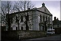
The Former Ropewalk Methodist Chapel, Knottingley
The former Ropewalk Methodist Chapel, Knottingley, in 1977, shortly before its demolition. The Wesley Hall, pictured in the background, provided a large hall and associated facilities for the Ropewalk Methodist Church alongside the Chapel. This building remains and now serves as a dual purpose place of worship and meeting hall.
Image: © Robert Neilson
Taken: Unknown
0.09 miles
3
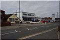
Springfield Garage on Weeland Road, Knottingley
Image: © Ian S
Taken: 7 Aug 2014
0.11 miles
4
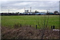
Fernley Green Industrial Estate and glass factory
Image: © Roger Templeman
Taken: 26 Mar 2016
0.14 miles
5
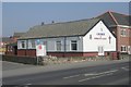
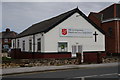
Salvation Army Church & Community Centre - Weeland Road
Image: © Betty Longbottom
Taken: 21 Mar 2009
0.14 miles
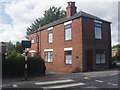
7
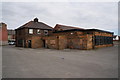
Knottingley Club on Weeland Road
This club is now a Sam Smith's Public House. http://www.geograph.org.uk/photo/4108295 http://www.geograph.org.uk/photo/4108288
Image: © Ian S
Taken: 7 Aug 2014
0.15 miles
8
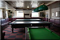
The Bar at Knottingley Club
This club is now a Sam Smith's Public House
Image: © Ian S
Taken: 7 Aug 2014
0.15 miles
9
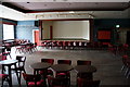
Concert Room at Knottingley Club
This club is now a Sam Smith's Public House. All but one (The Ebor) Sam Smith's pubs/clubs have no music or TV's, so this room is no longer used to hold concerts.
Image: © Ian S
Taken: 7 Aug 2014
0.15 miles