IMAGES TAKEN NEAR TO
Woodalls Buildings, KNOTTINGLEY, WF11 8BA
Introduction
This page details the photographs taken nearby to Woodalls Buildings, WF11 8BA by members of the Geograph project.
The Geograph project started in 2005 with the aim of publishing, organising and preserving representative images for every square kilometre of Great Britain, Ireland and the Isle of Man.

There are currently over 7.5m images from over14,400 individuals and you can help contribute to the project by visiting https://www.geograph.org.uk
Image Map
Images are licensed for reuse under creativecommons.org/licenses/by-sa/2.0
Notes
- Clicking on the map will re-center to the selected point.
- The higher the marker number, the further away the image location is from the centre of the postcode.
Image Listing (164 Images Found)
Images are licensed for reuse under creativecommons.org/licenses/by-sa/2.0
Image
Details
Distance
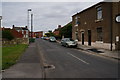
1
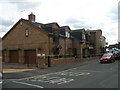
Jennings Funeral Services - Racca Green
Image: © Betty Longbottom
Taken: 27 Aug 2010
0.02 miles
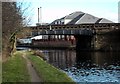
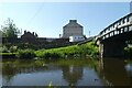
4
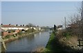
Canal beside Cow Lane Bridge
The Aire and Calder Navigation in Knottingley, east of Cow Lane Bridge.
Image: © DS Pugh
Taken: 27 May 2023
0.05 miles
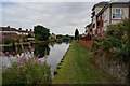
5
Aire & Calder Navigation - Racca Green
Image: © Betty Longbottom
Taken: 21 Mar 2009
0.05 miles
6
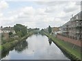
Aire & Calder Navigation - Racca Green
Image: © Betty Longbottom
Taken: 27 Aug 2010
0.05 miles
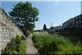
7
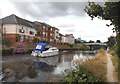
Racca Green Knottingley
Pleasure boat approaching Racca Green bridge on the Goole and Knottingley canal.
Image: © derek dye
Taken: 25 Jul 2016
0.05 miles
9

Knottingley Pet & Garden Supplies - Racca Green
Image: © Betty Longbottom
Taken: 27 Aug 2010
0.05 miles
10
Cow Lane Bridge
The Aire and Calder Navigation in Knottingley.
Image: © DS Pugh
Taken: 27 May 2023
0.05 miles