
IMAGES TAKEN NEAR TO
Weeland Road, KNOTTINGLEY, WF11 8AP
Introduction
This page details the photographs taken nearby to Weeland Road, WF11 8AP by members of the Geograph project.
The Geograph project started in 2005 with the aim of publishing, organising and preserving representative images for every square kilometre of Great Britain, Ireland and the Isle of Man.

There are currently over 7.5m images from over14,400 individuals and you can help contribute to the project by visiting https://www.geograph.org.uk
Image Map
Images are licensed for reuse under creativecommons.org/licenses/by-sa/2.0
Notes
- Clicking on the map will re-center to the selected point.
- The higher the marker number, the further away the image location is from the centre of the postcode.
Image Listing (166 Images Found)
Images are licensed for reuse under creativecommons.org/licenses/by-sa/2.0
Image
Details
Distance
3

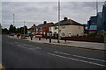
Stolzle & Rockware Sports & Social Club
Knottingley.
Image: © Ian S
Taken: 7 Aug 2014
0.03 miles
5
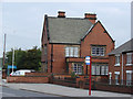
Knottingley Police Station, Weeland Road, Knottingley
Image: © Bill Henderson
Taken: 18 Sep 2006
0.05 miles

7
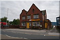
Jklbikes.com on Weeland Road, Knottingley
The former Knottingley Police Station.
Image: © Ian S
Taken: 7 Aug 2014
0.07 miles
8

Stolzle Flacconage, Knottingley
A glass container/bottle works in Knottingley. It was misty and getting dark but as I rarely come this way it had to be photographed.
Image: © Chris Allen
Taken: 26 Nov 2016
0.07 miles
10
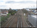
The view from England Lane footbridge
Looking eastwards along the line opened by the Lancashire and Yorkshire Railway in 1848. The line was built to facilitate the export of coal through the simultaneously developed port of Goole. The line is still extensively used by freight trains principally serving Kellingley colliery, Eggborough power station, Drax power station and the docks at Goole. There is also a minimal passenger service.
Image: © Jonathan Thacker
Taken: 19 Apr 2013
0.07 miles