IMAGES TAKEN NEAR TO
Lower Oxford Street, CASTLEFORD, WF10 4AQ
Introduction
This page details the photographs taken nearby to Lower Oxford Street, WF10 4AQ by members of the Geograph project.
The Geograph project started in 2005 with the aim of publishing, organising and preserving representative images for every square kilometre of Great Britain, Ireland and the Isle of Man.

There are currently over 7.5m images from over14,400 individuals and you can help contribute to the project by visiting https://www.geograph.org.uk
Image Map
Images are licensed for reuse under creativecommons.org/licenses/by-sa/2.0
Notes
- Clicking on the map will re-center to the selected point.
- The higher the marker number, the further away the image location is from the centre of the postcode.
Image Listing (306 Images Found)
Images are licensed for reuse under creativecommons.org/licenses/by-sa/2.0
Image
Details
Distance

2

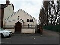
Castleford National Spiritualist Church - Lower Oxford Street
Image: © Betty Longbottom
Taken: 18 Aug 2010
0.02 miles
3

Jumbo House Takeaway - Lower Oxford Street
Image: © Betty Longbottom
Taken: 18 Aug 2010
0.02 miles
4
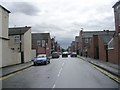
Vickers Street - Lower Oxford Street
Image: © Betty Longbottom
Taken: 18 Aug 2010
0.03 miles
5
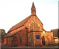
Spiritualist Church, Lower Oxford Street, Castleford
See also Image
Image: © Stephen Craven
Taken: 21 Mar 2022
0.03 miles


8

Vickers Street Fisheries - Vickers Street
Image: © Betty Longbottom
Taken: 18 Aug 2010
0.04 miles
9

Castleford Angling Supplies - Lower Oxford Street
Image: © Betty Longbottom
Taken: 18 Aug 2010
0.04 miles
10
St Joseph's Roman Catholic Church, Castleford.
Image: © Bill Henderson
Taken: Unknown
0.05 miles