IMAGES TAKEN NEAR TO
Henson Grove, CASTLEFORD, WF10 3JE
Introduction
This page details the photographs taken nearby to Henson Grove, WF10 3JE by members of the Geograph project.
The Geograph project started in 2005 with the aim of publishing, organising and preserving representative images for every square kilometre of Great Britain, Ireland and the Isle of Man.

There are currently over 7.5m images from over14,400 individuals and you can help contribute to the project by visiting https://www.geograph.org.uk
Image Map
Images are licensed for reuse under creativecommons.org/licenses/by-sa/2.0
Notes
- Clicking on the map will re-center to the selected point.
- The higher the marker number, the further away the image location is from the centre of the postcode.
Image Listing (42 Images Found)
Images are licensed for reuse under creativecommons.org/licenses/by-sa/2.0
Image
Details
Distance
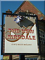
5
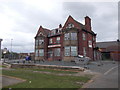
The New Airedale - Fryston Road
Despite a sign on the side assuring customers of a warm welcome, in its present state this pub is unlikely to any patrons!
Image: © Betty Longbottom
Taken: 25 Apr 2017
0.07 miles
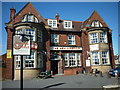
10
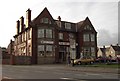
The New Airedale Public House
The New Airedale public house from across the road.
Image: © Darren Haddock
Taken: 22 Aug 2006
0.11 miles