
IMAGES TAKEN NEAR TO
Princess Street, CASTLEFORD, WF10 2RS
Introduction
This page details the photographs taken nearby to Princess Street, WF10 2RS by members of the Geograph project.
The Geograph project started in 2005 with the aim of publishing, organising and preserving representative images for every square kilometre of Great Britain, Ireland and the Isle of Man.

There are currently over 7.5m images from over14,400 individuals and you can help contribute to the project by visiting https://www.geograph.org.uk
Image Map
Images are licensed for reuse under creativecommons.org/licenses/by-sa/2.0
Notes
- Clicking on the map will re-center to the selected point.
- The higher the marker number, the further away the image location is from the centre of the postcode.
Image Listing (45 Images Found)
Images are licensed for reuse under creativecommons.org/licenses/by-sa/2.0
Image
Details
Distance
1
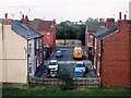
Greek Street, Castleford
No idea how this short street off Wheldon Road got its exotic name - among its neighbours are Swiss Street and Brazil Street. The floodlights above the roofs to the left are at Castleford Tigers rugby league club's Wheldon Road ground, a.k.a. the Jungle.
Image: © David Pickersgill
Taken: 13 Sep 2007
0.03 miles
2
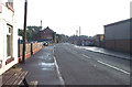
Wheldon Road, castleford, looking east from Castleford Tigers Rugby League ground
Image: © Bill Henderson
Taken: 5 Sep 2006
0.03 miles
3
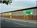
The Jungle. Home of the Castleford Tigers.
Image: © Jayne Claughton
Taken: 5 Jul 2006
0.03 miles
4
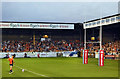
The Jungle Castleford Tigers Rugby league Ground
The night they won the league leaders shield, for the first time in their history.
Image: © derek dye
Taken: 17 Aug 2017
0.06 miles
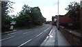

7
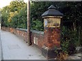
Wheldon Lane school
The cornerpost and wall are all that remain of Wheldon Lane school, opened by Castleford School Board in 1877, closed in the early 1980s and demolished in 1989. The stone plaque in the wall commemorates the opening of the second building on the site, in 1894.
Image: © David Pickersgill
Taken: Unknown
0.07 miles
8
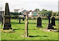
Castleford Cemetery
A corner of the northern half of the cemetery with just a few of the Victorian gravestones remaining. The obelisk on the left is a memorial to members of the Lumb family of bottlemakers, one among the many 19th century Castleford industrialists whose graves can be found here. Fawcett's maltkilns in the background.
Image: © David Pickersgill
Taken: 9 Sep 2007
0.08 miles
9
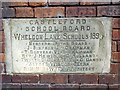
Wheldon Lane school
Plaque marking the enlargement of the school in 1894. The School Board mainly comprised local businessmen and church ministers, although Gabriel Dando was a colliery clerk.
Image: © David Pickersgill
Taken: Unknown
0.09 miles
10

Wheldon Road, Castleford, looking west from Castleford Tigers Rugby ground towards Castleford Town centre.
Image: © Bill Henderson
Taken: 6 Sep 2006
0.09 miles