
IMAGES TAKEN NEAR TO
Fryston Road, CASTLEFORD, WF10 2PX
Introduction
This page details the photographs taken nearby to Fryston Road, WF10 2PX by members of the Geograph project.
The Geograph project started in 2005 with the aim of publishing, organising and preserving representative images for every square kilometre of Great Britain, Ireland and the Isle of Man.

There are currently over 7.5m images from over14,400 individuals and you can help contribute to the project by visiting https://www.geograph.org.uk
Image Map
Images are licensed for reuse under creativecommons.org/licenses/by-sa/2.0
Notes
- Clicking on the map will re-center to the selected point.
- The higher the marker number, the further away the image location is from the centre of the postcode.
Image Listing (34 Images Found)
Images are licensed for reuse under creativecommons.org/licenses/by-sa/2.0
Image
Details
Distance
1
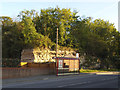
Bus stop on Wheldon Road, New Fryston
Behind the bus stop is an exposed limestone rock face. Old maps showed that the road to Wheldale Lodge ran along the top of this, with the area to the left being a 'lias lime works' (this would be for hydraulic lime mortar).
Image: © Stephen Craven
Taken: 14 May 2019
0.10 miles
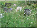
3
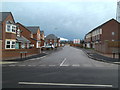
New Housing at Fryston
New housing in what was once an old Quarry. In its time it was an Athletics arena. Roller-skate rink, Car scrapyard and more recently a landfill site before being re-developed for new housing.
Image: © derek dye
Taken: 27 Jan 2012
0.11 miles
4
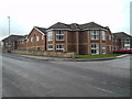
Fairburn View Residential Home Fryston Castleford
Image: © derek dye
Taken: 27 Jan 2012
0.12 miles
5

Site of St Peter's church, Fryston
St Peter's, which stood in the gap between these trees, has been described as an unconsecrated church of wood structure and corrugated metal cladding, dating from 1896. The ecclesiastical district of Airedale with Fryston was created on 15 May 1930 from parts of Ferry Fryston, All Saints Pontefract and St Paul Glass Houghton. The church was closed in 1990 following the closure of the colliery whose workers it served, and demolished some time between then and 2014. The housing block behind the trees to the left was erected on part of the closed churchyard; the remainder is maintained by Wakefield Council.
Image: © Stephen Craven
Taken: 14 May 2019
0.14 miles
6
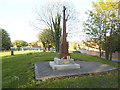
New Fryston War Memorial
The memorial stands in a closed churchyard. St Peter's church closed in 1990 following the closure of the nearby colliery and was demolished some time between then and 2014.
Image: © Stephen Craven
Taken: 14 May 2019
0.14 miles
7
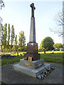
New Fryston War Memorial
The memorial stands in a closed churchyard. St Peter's church closed in 1990 following the closure of the nearby colliery and was demolished some time between then and 2014.
Image: © Stephen Craven
Taken: 14 May 2019
0.14 miles
8
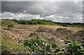
Part of Fryston Mine
Thought to have been the landsales part of Fryston mine now awaiting redevelopment.
Image: © roger geach
Taken: 11 Aug 2010
0.14 miles
9
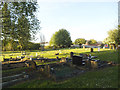
New Fryston churchyard, looking north-east
St Peter's church closed in 1990 and the closed churchyard is maintained by Wakefield Council.
Image: © Stephen Craven
Taken: 14 May 2019
0.15 miles
10

Fryston
The bridge over the railway is behind me. There is a cemetery on the right while derelict land a plenty behind the fence on the left.
Image: © roger geach
Taken: 11 Aug 2010
0.15 miles