IMAGES TAKEN NEAR TO
Dunderdale Crescent, CASTLEFORD, WF10 2NB
Introduction
This page details the photographs taken nearby to Dunderdale Crescent, WF10 2NB by members of the Geograph project.
The Geograph project started in 2005 with the aim of publishing, organising and preserving representative images for every square kilometre of Great Britain, Ireland and the Isle of Man.

There are currently over 7.5m images from over14,400 individuals and you can help contribute to the project by visiting https://www.geograph.org.uk
Image Map
Images are licensed for reuse under creativecommons.org/licenses/by-sa/2.0
Notes
- Clicking on the map will re-center to the selected point.
- The higher the marker number, the further away the image location is from the centre of the postcode.
Image Listing (4 Images Found)
Images are licensed for reuse under creativecommons.org/licenses/by-sa/2.0
Image
Details
Distance
1
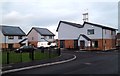
Energy efficient housing estate at Castleford
A new housing development, using all the latest energy saving construction techniques on the old Parkdale estate in Airedale Castleford West Yorkshire.
Image: © derek dye
Taken: 27 Jan 2012
0.05 miles
4
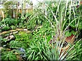
Garden pond, Little Eden, Castleford
A well-named garden, opened as part of the NGS scheme.
Image: © Christine Johnstone
Taken: 24 Jun 2012
0.09 miles