IMAGES TAKEN NEAR TO
Theobald Street, RADLETT, WD7 7LR
Introduction
This page details the photographs taken nearby to Theobald Street, WD7 7LR by members of the Geograph project.
The Geograph project started in 2005 with the aim of publishing, organising and preserving representative images for every square kilometre of Great Britain, Ireland and the Isle of Man.

There are currently over 7.5m images from over14,400 individuals and you can help contribute to the project by visiting https://www.geograph.org.uk
Image Map
Images are licensed for reuse under creativecommons.org/licenses/by-sa/2.0
Notes
- Clicking on the map will re-center to the selected point.
- The higher the marker number, the further away the image location is from the centre of the postcode.
Image Listing (4 Images Found)
Images are licensed for reuse under creativecommons.org/licenses/by-sa/2.0
Image
Details
Distance
3
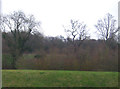
Grass bank and woodland near Tykes Water, Radlett
Image: © JThomas
Taken: 18 Mar 2017
0.23 miles
4
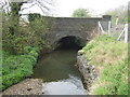
Radlett Brook: Railway bridge
Radlett Brook swings around a curve from the left and passes under the Midland Mainline railway here. On the inside of the bend, to the left, the brook has deposited a shingly shoal while on the right, on the outside of the bend, it has been necessary to place gabions (stones or rocks encased in a wire frame) to protect the bank from erosion. Please see Image for an illustration of cartographic licence here.
Image: © Nigel Cox
Taken: 15 Apr 2009
0.24 miles