IMAGES TAKEN NEAR TO
Williams Way, RADLETT, WD7 7HA
Introduction
This page details the photographs taken nearby to Williams Way, WD7 7HA by members of the Geograph project.
The Geograph project started in 2005 with the aim of publishing, organising and preserving representative images for every square kilometre of Great Britain, Ireland and the Isle of Man.

There are currently over 7.5m images from over14,400 individuals and you can help contribute to the project by visiting https://www.geograph.org.uk
Image Map
Images are licensed for reuse under creativecommons.org/licenses/by-sa/2.0
Notes
- Clicking on the map will re-center to the selected point.
- The higher the marker number, the further away the image location is from the centre of the postcode.
Image Listing (9 Images Found)
Images are licensed for reuse under creativecommons.org/licenses/by-sa/2.0
Image
Details
Distance
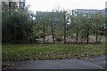
1
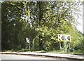
Radlett: Williams Way
Fine late autumn colour of oak trees on the Williams Way green, viewed looking northwards at the junction with Newberries Avenue.
Image: © Nigel Cox
Taken: 10 Dec 2005
0.02 miles
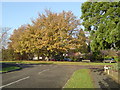
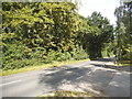
2
Williams Way at the junction of Craigweil Avenue
Image: © David Howard
Taken: 6 Aug 2015
0.07 miles
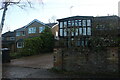
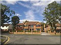
8
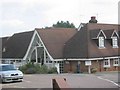
Porters Park Golf Club House, Radlett
The club is obviously a successful one judging by the buildings and size of car park
Image: © Jack Hill
Taken: 15 Aug 2005
0.22 miles