IMAGES TAKEN NEAR TO
Hartforde Road, BOREHAMWOOD, WD6 5HU
Introduction
This page details the photographs taken nearby to Hartforde Road, WD6 5HU by members of the Geograph project.
The Geograph project started in 2005 with the aim of publishing, organising and preserving representative images for every square kilometre of Great Britain, Ireland and the Isle of Man.

There are currently over 7.5m images from over14,400 individuals and you can help contribute to the project by visiting https://www.geograph.org.uk
Image Map
Images are licensed for reuse under creativecommons.org/licenses/by-sa/2.0
Notes
- Clicking on the map will re-center to the selected point.
- The higher the marker number, the further away the image location is from the centre of the postcode.
Image Listing (24 Images Found)
Images are licensed for reuse under creativecommons.org/licenses/by-sa/2.0
Image
Details
Distance
1

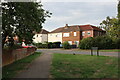
Swimming Baths at Borehamwood
These baths are brand spanking new
Image: © Jack Hill
Taken: 7 Jul 2005
0.03 miles
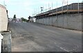
3
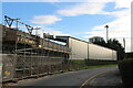
Meadow Park Stadium, Borehamwood
Currently being rebuilt, this is the home of Borehamwood FC.
Image: © David Howard
Taken: 4 Sep 2022
0.09 miles
4
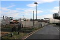
Construction work at Borehamwood FC
The whole stadium is being rebuilt.
Image: © David Howard
Taken: 4 Sep 2022
0.10 miles
5

The pedestrian entrance to Borehamwood FC
This is all in the process of construction.
Image: © David Howard
Taken: 4 Sep 2022
0.11 miles
6
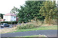
Meadow Park, Borehamwood
Looking towards Broughinge Road.
Image: © David Howard
Taken: 4 Sep 2022
0.12 miles
7
The entrance to Borehamwood FC
The ground is currently being rebuilt and this is the road entrance which is not yet in use, the pedestrian entrance runs parallel to the left.
Image: © David Howard
Taken: 4 Sep 2022
0.12 miles
8
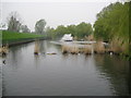
Borehamwood: Aberford Park Lake
The lake is man-made and on the course of Borehamwood Brook. It serves as the main repository for surface water run-off in the town. For a close-up of the fountain see Image The patches of reeds in the foreground are in use as nesting sites by the lake's colony of coots.
Image: © Nigel Cox
Taken: 15 Apr 2009
0.13 miles
9
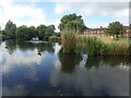
Lake in Aberford Park
Aberford Park was purchased in stages starting in 1888. The lake was formed by the damming of the Borehamwood Brook. On some maps this is known as Tykes Water.
More information can be found at https://www.greenflagaward.org//park-summary/?park=576 and https://www.parksherts.co.uk/parks/view/aberford-park
Image: © Marathon
Taken: 25 May 2022
0.13 miles
10
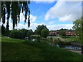
Aberford Park
Aberford Park was purchased in stages starting in 1888. The lake was formed by the damming of the Borehamwood Brook. On some maps this is known as Tykes Water.
More information can be found at https://www.greenflagaward.org//park-summary/?park=576 and https://www.parksherts.co.uk/parks/view/aberford-park
See also https://www.geograph.org.uk/photo/7182331
Image: © Marathon
Taken: 25 May 2022
0.13 miles